
Mapa topográfico St. John's in the Vale
Mapa interactivo
Haga clic en el mapa para ver la altitud.
Acerca de este mapa
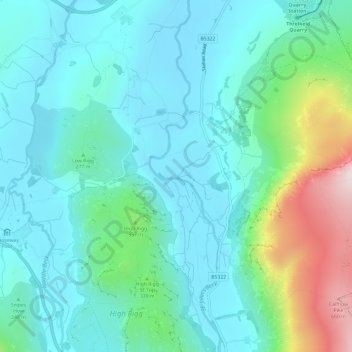
Nombre: Mapa topográfico St. John's in the Vale, altitud, relieve.
Altitud media: 256 m
Altitud mínima: 134 m
Altitud máxima: 706 m
Otros mapas topográficos
Haga clic en un mapa para ver su topografía, su altitud y su relieve.
St. John's Beck
United Kingdom > England > Cumberland > Legburthwaite
St. John's Beck, Legburthwaite, Cumberland, England, CA12 4TG, United Kingdom
Altitud media: 311 m