
Mapa topográfico Iturup
Mapa interactivo
Haga clic en el mapa para ver la altitud.
Iturup
The deposits of the Vetrovoy Isthmus include volcanic-tectonic dislocations, pumice pyroclastics, aeolian-ash deposits and soil-tephra formations. The morphometric parameters of the basement terrace indicate an area elevation rate during the last phase of coastal marine accumulation that could reach 4 mm/year, slightly higher than the 3.5 m/year recorded during the last 6000 thousand years.
Acerca de este mapa
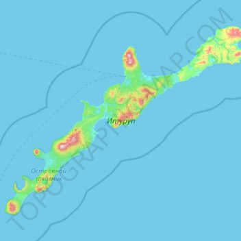
Nombre: Mapa topográfico Iturup, altitud, relieve.
Altitud media: 31 m
Altitud mínima: 0 m
Altitud máxima: 1.605 m