
Haz una donación
Equípate para tu próxima aventura:
Como asociado de Amazon, este sitio gana comisiones por las compras que califican, sin ningún costo adicional para usted.
Mapa topográfico Huangshi
Haga clic en el mapa para ver la altitud.
Haz una donación
Equípate para tu próxima aventura:
Como asociado de Amazon, este sitio gana comisiones por las compras que califican, sin ningún costo adicional para usted.
Huangshi
Huangshi is located in southeastern Hubei province, primarily along the southwestern bank of one of the major bends in the Yangtze River. It is located 100 kilometers (62 mi) southeast of Wuhan, and borders Jiangxi province to the south. Its area was reported by the local government as 4,583 square kilometers (1,770 sq mi); elsewhere, the number of 4,630 square kilometers (1,790 sq mi) was given. The terrain is mostly small mountains and hills. The tallest mountain is 7 Summit Mountain with an elevation of 860 meters (2,820 ft) above sea level. Huangshi is also located in a major lake district between Hunan's Dongting Lake and Jiangxi's Poyang lake and has dozens of large lakes. Huangshi's climate is sub-temperate. Average annual temperature is 17 °C (63 °F) and precipitation is 1,400 mm (55.1 in). There are 264 frost free days. It is possible to see limited snowfall between December and February.
Haz una donación
Equípate para tu próxima aventura:
Como asociado de Amazon, este sitio gana comisiones por las compras que califican, sin ningún costo adicional para usted.
Acerca de este mapa
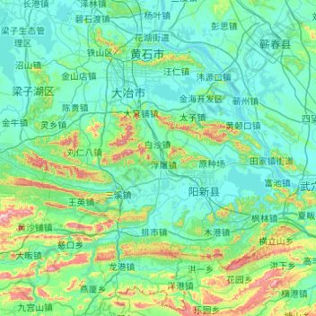
Nombre: Mapa topográfico Huangshi, altitud, relieve.
Lugar: Huangshi, Hubei, China (29.50855 114.52622 30.32826 115.50517)
Altitud media: 123 m
Altitud mínima: 8 m
Altitud máxima: 924 m
Haz una donación
Equípate para tu próxima aventura:
Como asociado de Amazon, este sitio gana comisiones por las compras que califican, sin ningún costo adicional para usted.