
Mapa topográfico Fouday
Mapa interactivo
Haga clic en el mapa para ver la altitud.
Acerca de este mapa
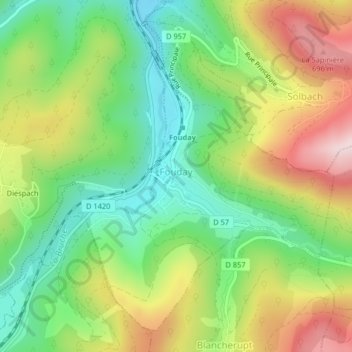
Nombre: Mapa topográfico Fouday, altitud, relieve.
Altitud media: 519 m
Altitud mínima: 373 m
Altitud máxima: 725 m
The village is served by the National Road (Route nationale) 420 which connects Strasbourg with Saint-Dié. The town is also traversed by the railway line - here just a single track - that connects these two urban centres. The mountain topography of the region keeps the road and railway running in close parallel along the Bruche Valley.