
Mapa topográfico Sandy Point
Mapa interactivo
Haga clic en el mapa para ver la altitud.
Acerca de este mapa
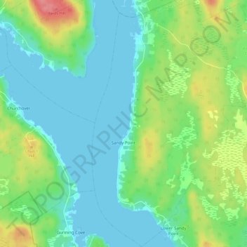
Nombre: Mapa topográfico Sandy Point, altitud, relieve.
Altitud media: 23 m
Altitud mínima: -1 m
Altitud máxima: 84 m
Otros mapas topográficos
Haga clic en un mapa para ver su topografía, su altitud y su relieve.
Barrington Passage
Canada > Nova Scotia > Shelburne County > Barrington Passage
Barrington Passage, Municipality of the District of Barrington, Shelburne County, Nova Scotia, B0W 1E0, Canada
Altitud media: 13 m
Rocky Creek
Canada > Nova Scotia > Shelburne County > Lower Clyde River
Rocky Creek, Lower Clyde River, Municipality of the District of Barrington, Shelburne County, Nova Scotia, B0W 1R0, Canada
Altitud media: 48 m
West Head
Canada > Nova Scotia > Shelburne County
West Head, Municipality of the District of Barrington, Shelburne County, Nova Scotia, B0W 3B0, Canada
Altitud media: 3 m
Blacksmiths Beach
Canada > Nova Scotia > Shelburne County > Cape Negro Island
Blacksmiths Beach, Cape Negro Island, Municipality of the District of Barrington, Shelburne County, Nova Scotia, B0W 1K0, Canada
Altitud media: 2 m