
Mapa topográfico Coventry
Mapa interactivo
Haga clic en el mapa para ver la altitud.
Acerca de este mapa
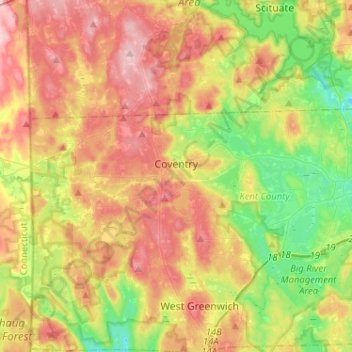
Nombre: Mapa topográfico Coventry, altitud, relieve.
Lugar: Coventry, Kent County, Rhode Island, United States (41.65605 -71.78970 41.73021 -71.53309)
Altitud media: 126 m
Altitud mínima: 47 m
Altitud máxima: 213 m
Otros mapas topográficos
Haga clic en un mapa para ver su topografía, su altitud y su relieve.
Warwick
United States > Rhode Island > Kent County
Warwick, Kent County, Rhode Island, United States
Altitud media: 16 m
West Warwick
United States > Rhode Island > Kent County
West Warwick, Kent County, Rhode Island, United States
Altitud media: 59 m
Masonic - Shriners Family Center
United States > Rhode Island > Kent County > Warwick
Masonic - Shriners Family Center, Warwick, Kent County, Rhode Island, United States
Altitud media: 7 m
West Warwick
United States > Rhode Island > Kent County
West Warwick, Kent County, Rhode Island, 02893, United States
Altitud media: 60 m
Hell's Half Acre
United States > Rhode Island > Kent County > West Greenwich
Hell's Half Acre, West Greenwich, Kent County, Rhode Island, 02822, United States
Altitud media: 110 m
Crompton
United States > Rhode Island > Kent County > West Warwick
Crompton, West Warwick, Kent County, Rhode Island, 02893, United States
Altitud media: 63 m
East Greenwich
United States > Rhode Island > Kent County
East Greenwich, Kent County, Rhode Island, 02818, United States
Altitud media: 21 m
Greene
United States > Rhode Island > Kent County > Coventry > Greene
Greene, Coventry, Kent County, Rhode Island, 02827, United States
Altitud media: 139 m
West Greenwich
United States > Rhode Island > Kent County
West Greenwich, Kent County, Rhode Island, 02817, United States
Altitud media: 111 m