
Mapa topográfico Capiz
Mapa interactivo
Haga clic en el mapa para ver la altitud.
Acerca de este mapa
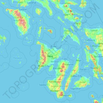
Nombre: Mapa topográfico Capiz, altitud, relieve.
Lugar: Capiz, Western Visayas, Philippines (8.82530 120.07773 13.94530 125.19773)
Altitud media: 56 m
Altitud mínima: -2 m
Altitud máxima: 2.428 m
Capiz covers a total area of 2,594.64 square kilometres (1,001.80 sq mi) occupying the northeastern portion of Panay Island, and is one of the five provinces that compose the Western Visayas region. Mount Nangtud, is the highest mountain in Capiz with an elevation of 6,800 ft ( 2,073 m) located in the Capiz-Antique border. Other peaks are Mount Tigas 4,760 ft (1,451m), Mount Agudo 2,736 ft (834m). The province comprises 473 barangays, 16 municipalities and a city. Roxas City, the provincial capital, is only 45 minutes away by plane from Manila and is within the routes of major shipping lines. The Panay River used to be famous for the great number of crocodiles thriving there. Capiz is bounded by the Sibuyan Sea, the Panay, Loctugan and Ivisan rivers.
Otros mapas topográficos
Haga clic en un mapa para ver su topografía, su altitud y su relieve.