
Mapa topográfico Conthey
Mapa interactivo
Haga clic en el mapa para ver la altitud.
Acerca de este mapa
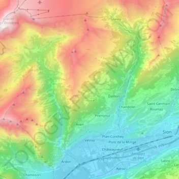
Nombre: Mapa topográfico Conthey, altitud, relieve.
Lugar: Conthey, Gundis, Wallis, 1964, Schweiz (46.20412 7.15116 46.31640 7.33059)
Altitud media: 1.451 m
Altitud mínima: 473 m
Altitud máxima: 3.194 m
Die Gemeinde erstreckt sich vom Tsanfleurongletscher an der Grenze zum Kanton Waadt bis hinunter an das Ufer der Rhone, von über 3000 m ü. M. bis 460 m ü. M. Sie besteht aus den zehn Ortschaften Aven, Châteauneuf, Conthey, Daillon, Erde, Le Bourg, Premploz, Sensine, St-Séverin und Vens zusammen, wobei sich die grössten – Plan-Conthey und Châteauneuf – in der Rhône-Ebene befinden, kleinere wie Sensine, Erde, Premploz oder Daillon auf verschiedenen Höhenstufen bis auf 930 m ü. M.
Otros mapas topográficos
Haga clic en un mapa para ver su topografía, su altitud y su relieve.