
Mapa topográfico Ingham County
Mapa interactivo
Haga clic en el mapa para ver la altitud.
Acerca de este mapa
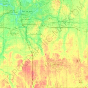
Nombre: Mapa topográfico Ingham County, altitud, relieve.
Lugar: Ingham County, Michigan, United States of America (42.42196 -84.60314 42.77660 -84.14060)
Altitud media: 278 m
Altitud mínima: 246 m
Altitud máxima: 319 m
The county consists of gently rolling hills with an elevation ranging between 800 and 1,000 feet above sea level. The highest point in the county is the top of Teaspoon Hill rising to a height of 1,056 feet above sea level 1.5 miles north of Leslie.
Otros mapas topográficos
Haga clic en un mapa para ver su topografía, su altitud y su relieve.
Genesee County
United States of America > Michigan
Genesee County, Michigan, United States of America
Altitud media: 246 m
Ontonagon County
United States of America > Michigan
Ontonagon County, Michigan, United States of America
Altitud media: 334 m
Sanilac County
United States of America > Michigan
Sanilac County, Michigan, United States of America
Altitud media: 228 m
East Lansing
United States of America > Michigan > East Lansing > East Lansing
East Lansing, Ingham County, Michigan, United States of America
Altitud media: 261 m