
Mapa topográfico 扯旗山 Victoria Peak
Mapa interactivo
Haga clic en el mapa para ver la altitud.
Acerca de este mapa
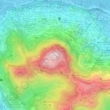
Nombre: Mapa topográfico 扯旗山 Victoria Peak, altitud, relieve.
Lugar: 扯旗山 Victoria Peak, Hong Kong Island, Hongkong, China (22.27599 114.14541 22.27609 114.14551)
Altitud media: 209 m
Altitud mínima: -2 m
Altitud máxima: 534 m
Der Victoria Peak (chinesisch 太平山, Pinyin Tàipíng Shān, Jyutping Taai3ping4 Saan1 – „Friedensberg“) mit 552 Metern Höhe ist der bekannteste Berg Hongkongs. Auf Hong Kong Island gelegen, ist er zugleich die höchste Erhebung dieser Insel, wird jedoch vom 958 Meter hohen, in den New Territories gelegenen Tai Mo Shan deutlich überragt. Sein chinesischer Name Tai Ping Shan bedeutet „Berg des großen Friedens“. Der Gipfel bietet einen weiten Blick über Kowloon und große Teile der Insel Hongkong.
Otros mapas topográficos
Haga clic en un mapa para ver su topografía, su altitud y su relieve.
Victoria Peak Lookout (over the Victoria Harbour)
China > Hongkong > Hong Kong Island
Victoria Peak Lookout (over the Victoria Harbour), 盧吉道 Lugard Road, 太平山 Victoria Peak, 山頂 The Peak, 中西區 Central and Western District, Hong Kong Island, Hongkong, China
Altitud media: 191 m
Southern District
China > Hongkong > Hong Kong Island
Southern District, Hong Kong Island, Hongkong, China
Altitud media: 36 m
中區 Central District
China > Hongkong > Hong Kong Island
中區 Central District, Hong Kong Island, Hongkong, China
Altitud media: 114 m