
Mapa topográfico Beverstedt
Mapa interactivo
Haga clic en el mapa para ver la altitud.
Acerca de este mapa
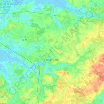
Nombre: Mapa topográfico Beverstedt, altitud, relieve.
Lugar: Beverstedt, Landkreis Cuxhaven, Lower Saxony, 27616, Germany (53.37253 8.67047 53.52149 8.97320)
Altitud media: 12 m
Altitud mínima: -4 m
Altitud máxima: 40 m
Otros mapas topográficos
Haga clic en un mapa para ver su topografía, su altitud y su relieve.
21769
Germany > Lower Saxony > Landkreis Cuxhaven > Lamstedt
21769, Lamstedt, Samtgemeinde Börde Lamstedt, Landkreis Cuxhaven, Lower Saxony, Germany
Altitud media: 24 m