
Mapa topográfico Macon
Mapa interactivo
Haga clic en el mapa para ver la altitud.
Macon
The Ocmulgee River is a major river that runs through the city. Macon is one of Georgia's three major Fall Line Cities, along with Augusta and Columbus. The Fall Line is where the hilly lands of the Piedmont plateau meet the flat terrain of the coastal plain. As such, Macon has a varied landscape of rolling hills on the north side and flat plains on the south. The fall line, where the altitude drops noticeably, causes rivers and creeks in the area to flow rapidly toward the ocean. In the past, Macon and other Fall Line cities had many textile mills powered by the rivers.
Acerca de este mapa
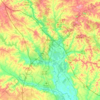
Nombre: Mapa topográfico Macon, altitud, relieve.
Lugar: Macon, Bibb County, Georgia, United States (32.66064 -83.89272 32.95287 -83.48943)
Altitud media: 127 m
Altitud mínima: 69 m
Altitud máxima: 210 m
Otros mapas topográficos
Haga clic en un mapa para ver su topografía, su altitud y su relieve.