
Mapa topográfico Pangasugan River
Mapa interactivo
Haga clic en el mapa para ver la altitud.
Acerca de este mapa
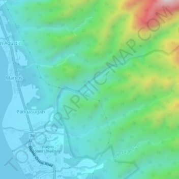
Nombre: Mapa topográfico Pangasugan River, altitud, relieve.
Altitud media: 194 m
Altitud mínima: 0 m
Altitud máxima: 872 m
Otros mapas topográficos
Haga clic en un mapa para ver su topografía, su altitud y su relieve.
Patag
Philippines > Leyte > Baybay
Patag, Baybay, 5th District, Leyte, Eastern Visayas, 6521, Philippines
Altitud media: 64 m
Palhi
Philippines > Leyte > Baybay
Palhi, Baybay, 5th District, Leyte, Eastern Visayas, 6521, Philippines
Altitud media: 20 m
Baybay
Philippines > Leyte > Baybay
Baybay, Leyte 5th District, Leyte, Eastern Visayas, 6521, Philippines
Altitud media: 163 m
Lower Utod (Guadalupe)
Philippines > Leyte > Baybay
Lower Utod (Guadalupe), Baybay, Leyte 5th District, Leyte, Eastern Visayas, 6521, Philippines
Altitud media: 29 m
Pagbanganan River
Philippines > Leyte > Baybay > Kantagnos
Pagbanganan River, Kantagnos, Baybay, Leyte 5th District, Leyte, Eastern Visayas, 6521, Philippines
Altitud media: 145 m
Mount Pangasugan
Philippines > Leyte > Baybay
Mount Pangasugan, Baybay, Leyte 5th District, Leyte, Eastern Visayas, 6521, Philippines
Altitud media: 712 m
Mailhi
Philippines > Leyte > Baybay > Mailhi
Mailhi, Baybay, Leyte 5th District, Leyte, Eastern Visayas, 6521, Philippines
Altitud media: 237 m
Caridad
Philippines > Leyte > Baybay
Caridad, Baybay, 5th District, Leyte, Eastern Visayas, 6521, Philippines
Altitud media: 33 m