Mapa topográfico Aberlour
Haga clic en el mapa para ver la altitud.
Aberlour
According to the 1846 A Topographical Dictionary of Scotland, "This parish, formerly called Skirdustan, signifying, in the Gaelic tongue, 'the division of Dustan', its tutelary saint, derived its present name from its situation at the mouth of a noisy burn, which discharges itself into the river Spey."
Acerca de este mapa
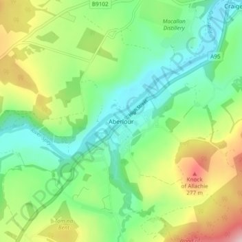
Nombre: Mapa topográfico Aberlour, altitud, relieve.
Lugar: Aberlour, Moray, Scotland, AB38 9PX, United Kingdom (57.45079 -3.24554 57.49079 -3.20554)
Altitud media: 160 m
Altitud mínima: 75 m
Altitud máxima: 326 m
Otros mapas topográficos
Haga clic en un mapa para ver su topografía, su altitud y su relieve.
Fochabers
United Kingdom > Scotland > Moray
The present village owes its existence to Alexander Gordon, 4th Duke of Gordon (1743–1827). During the late eighteenth century, during the Scottish Enlightenment, it was fashionable for landowners to found new towns and villages; these can be recognised all over Scotland, because unlike their predecessors…
Altitud media: 59 m