
Mapa topográfico Cumberland County
Mapa interactivo
Haga clic en el mapa para ver la altitud.
Acerca de este mapa
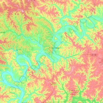
Nombre: Mapa topográfico Cumberland County, altitud, relieve.
Lugar: Cumberland County, Kentucky, United States of America (36.61853 -85.60121 36.93842 -85.21472)
Altitud media: 237 m
Altitud mínima: 157 m
Altitud máxima: 344 m
Otros mapas topográficos
Haga clic en un mapa para ver su topografía, su altitud y su relieve.
High Plains
United States of America > Kentucky > High Plains
High Plains, Breckinridge County, Kentucky, 40115, United States of America
Altitud media: 228 m
Covington
United States of America > Kentucky > Covington
Covington, Kenton County, Kentucky, United States of America
Altitud media: 215 m
Lawrenceburg
United States of America > Kentucky > Lawrenceburg > Lawrenceburg
Lawrenceburg, Anderson County, Kentucky, 40342, United States of America
Altitud media: 244 m
Pineville
United States of America > Kentucky > Pineville
Pineville, Bell County, Kentucky, United States of America
Altitud media: 426 m
Ready
United States of America > Kentucky > Ready
Ready, Grayson County, Kentucky, United States of America
Altitud media: 206 m
Monroe County
United States of America > Kentucky
Monroe County, Kentucky, United States of America
Altitud media: 250 m
Pomp
United States of America > Kentucky > Pomp
Pomp, Morgan County, Kentucky, 41472, United States of America
Altitud media: 282 m
Millard
United States of America > Kentucky > Millard
Nelse, Millard, Pike County, Kentucky, 41562, United States of America
Altitud media: 315 m
Metcalfe County
United States of America > Kentucky
Metcalfe County, Kentucky, United States of America
Altitud media: 251 m