
Haz una donación
Equípate para tu próxima aventura:
Como asociado de Amazon, este sitio gana comisiones por las compras que califican, sin ningún costo adicional para usted.
Mapa topográfico Eagle Rock
Haga clic en el mapa para ver la altitud.
Haz una donación
Equípate para tu próxima aventura:
Como asociado de Amazon, este sitio gana comisiones por las compras que califican, sin ningún costo adicional para usted.
Acerca de este mapa
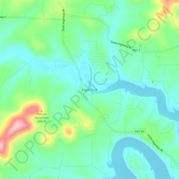
Nombre: Mapa topográfico Eagle Rock, altitud, relieve.
Lugar: Eagle Rock, Barry County, Missouri, 65641, United States (36.52812 -93.77436 36.56812 -93.73436)
Altitud media: 322 m
Altitud mínima: 276 m
Altitud máxima: 445 m
Haz una donación
Equípate para tu próxima aventura:
Como asociado de Amazon, este sitio gana comisiones por las compras que califican, sin ningún costo adicional para usted.
Otros mapas topográficos
Haga clic en un mapa para ver su topografía, su altitud y su relieve.
Haz una donación
Equípate para tu próxima aventura:
Como asociado de Amazon, este sitio gana comisiones por las compras que califican, sin ningún costo adicional para usted.
Purdy
United States > Missouri > Barry County
US Department of the Interior Original Surveys and USGS Topographical map showing the Butterfield Overland Mail Route
Altitud media: 445 m
Purdy
United States > Missouri > Barry County
US Department of the Interior Original Surveys and USGS Topographical map showing the Butterfield Overland Mail Route
Altitud media: 445 m
Haz una donación
Equípate para tu próxima aventura:
Como asociado de Amazon, este sitio gana comisiones por las compras que califican, sin ningún costo adicional para usted.