
Haz una donación
Equípate para tu próxima aventura:
Como asociado de Amazon, este sitio gana comisiones por las compras que califican, sin ningún costo adicional para usted.
Mapa topográfico Kawagarbo
Haga clic en el mapa para ver la altitud.
Haz una donación
Equípate para tu próxima aventura:
Como asociado de Amazon, este sitio gana comisiones por las compras que califican, sin ningún costo adicional para usted.
Kawagarbo
The Kawa Karpo has over 20 peaks with permanent snow cover, including six peaks over 6,000 m (19,700 ft). Topographic extremes are immense, with vertical relief ranging from less than 2,000 m along the Mekong River on the east to 6,740 m on the summit of Kawa Karpo within 10 km horizontal distance. Even greater topographic relief is found on the west or Salween River side of the range. Coincident with this extreme topographic gradient is a similarly steep environmental gradient. Compressed within this short distance are subtropical scrub ecosystems along the arid canyon bottoms, rising through dry oak forests, humid mixed deciduous-coniferous forests, cold temperate coniferous forests, alpine meadows and scree above treeline, to permanent snow on the high peaks. The Mingyong Glacier, descending from the summit of Kawa Karpo, terminates at a low elevation just before the subtropical life zone. The range is highly affected by the monsoon, leading to especially unstable snow conditions, which have affected climbing attempts (see below).
Haz una donación
Equípate para tu próxima aventura:
Como asociado de Amazon, este sitio gana comisiones por las compras que califican, sin ningún costo adicional para usted.
Acerca de este mapa
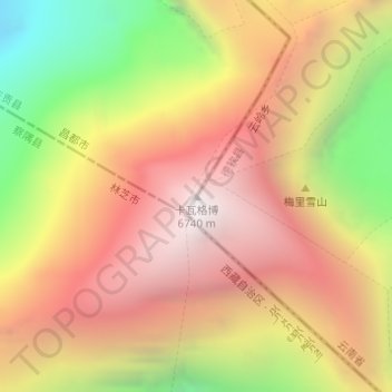
Nombre: Mapa topográfico Kawagarbo, altitud, relieve.
Lugar: Kawagarbo, Chamdo City, Tibet, China (28.43966 98.68435 28.43976 98.68445)
Altitud media: 5.809 m
Altitud mínima: 4.620 m
Altitud máxima: 6.698 m
Haz una donación
Equípate para tu próxima aventura:
Como asociado de Amazon, este sitio gana comisiones por las compras que califican, sin ningún costo adicional para usted.