
Haz una donación
Equípate para tu próxima aventura:
Como asociado de Amazon, este sitio gana comisiones por las compras que califican, sin ningún costo adicional para usted.
Mapa topográfico Burlington
Haga clic en el mapa para ver la altitud.
Haz una donación
Equípate para tu próxima aventura:
Como asociado de Amazon, este sitio gana comisiones por las compras que califican, sin ningún costo adicional para usted.
Acerca de este mapa
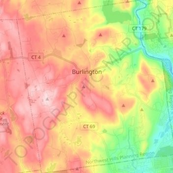
Nombre: Mapa topográfico Burlington, altitud, relieve.
Altitud media: 219 m
Altitud mínima: 61 m
Altitud máxima: 352 m
Haz una donación
Equípate para tu próxima aventura:
Como asociado de Amazon, este sitio gana comisiones por las compras que califican, sin ningún costo adicional para usted.
Otros mapas topográficos
Haga clic en un mapa para ver su topografía, su altitud y su relieve.
Apple Hill
United States > Connecticut > Northwest Hills Planning Region > Morris
Altitud media: 297 m
Northfield
United States > Connecticut > Northwest Hills Planning Region > Litchfield
Altitud media: 259 m
Bakerville
United States > Connecticut > Northwest Hills Planning Region > New Hartford
Altitud media: 244 m
Haystack Mountain
United States > Connecticut > Northwest Hills Planning Region > Norfolk
Altitud media: 385 m
Haz una donación
Equípate para tu próxima aventura:
Como asociado de Amazon, este sitio gana comisiones por las compras que califican, sin ningún costo adicional para usted.
Marble Dale
United States > Connecticut > Northwest Hills Planning Region > Washington
Altitud media: 249 m
Washington Depot
United States > Connecticut > Northwest Hills Planning Region > Washington
Altitud media: 231 m
Nelsons Corner
United States > Connecticut > Northwest Hills Planning Region > Winchester
Altitud media: 275 m
Nepaug
United States > Connecticut > Northwest Hills Planning Region > New Hartford
Altitud media: 222 m
Haz una donación
Equípate para tu próxima aventura:
Como asociado de Amazon, este sitio gana comisiones por las compras que califican, sin ningún costo adicional para usted.
West Torrington
United States > Connecticut > Northwest Hills Planning Region > Torrington
Altitud media: 270 m
Lakeville
United States > Connecticut > Northwest Hills Planning Region > Salisbury
Altitud media: 259 m
East Morris
United States > Connecticut > Northwest Hills Planning Region > Morris
Altitud media: 294 m
Haz una donación
Equípate para tu próxima aventura:
Como asociado de Amazon, este sitio gana comisiones por las compras que califican, sin ningún costo adicional para usted.
Wangum Village
United States > Connecticut > Northwest Hills Planning Region > Canaan
Altitud media: 235 m
Pleasant Valley
United States > Connecticut > Northwest Hills Planning Region > Barkhamsted
Altitud media: 192 m
Drakeville
United States > Connecticut > Northwest Hills Planning Region > Torrington
Altitud media: 309 m
Haz una donación
Equípate para tu próxima aventura:
Como asociado de Amazon, este sitio gana comisiones por las compras que califican, sin ningún costo adicional para usted.
Bartholomew Hill
United States > Connecticut > Northwest Hills Planning Region > Goshen
Altitud media: 426 m
Canaan Valley
United States > Connecticut > Northwest Hills Planning Region > North Canaan
Altitud media: 293 m
Bear Mountain
United States > Connecticut > Northwest Hills Planning Region > Salisbury
Bear Mountain is a peak of the southern Taconic Mountains in Salisbury, Connecticut. At 2,316 feet (706 m) (note, per references 1 and 3, there is disagreement about the precise elevation), Bear Mountain is the highest mountain that lies wholly within Connecticut. However, it is not the state highpoint: in the…
Altitud media: 544 m
The Matterhorn
United States > Connecticut > Northwest Hills Planning Region > Canaan
Altitud media: 462 m
Haz una donación
Equípate para tu próxima aventura:
Como asociado de Amazon, este sitio gana comisiones por las compras que califican, sin ningún costo adicional para usted.
Bear Mountain
United States > Connecticut > Northwest Hills Planning Region > Salisbury
Bear Mountain is a peak of the southern Taconic Mountains in Salisbury, Connecticut. At 2,316 feet (706 m) (note, per references 1 and 3, there is disagreement about the precise elevation), Bear Mountain is the highest mountain that lies wholly within Connecticut. However, it is not the state highpoint: in the…
Altitud media: 544 m
The Matterhorn
United States > Connecticut > Northwest Hills Planning Region > Canaan
Altitud media: 462 m
Lime Rock
United States > Connecticut > Northwest Hills Planning Region > Salisbury
Altitud media: 238 m
Northfield
United States > Connecticut > Northwest Hills Planning Region > Litchfield
Altitud media: 259 m
Haz una donación
Equípate para tu próxima aventura:
Como asociado de Amazon, este sitio gana comisiones por las compras que califican, sin ningún costo adicional para usted.
Bradford Mountain
United States > Connecticut > Northwest Hills Planning Region > Canaan
Altitud media: 470 m
Bulls Bridge
United States > Connecticut > Northwest Hills Planning Region > Kent
Altitud media: 178 m
Panorama Hill
United States > Connecticut > Northwest Hills Planning Region > Colebrook
Altitud media: 379 m
Bear Mountain
United States > Connecticut > Northwest Hills Planning Region > Salisbury
Bear Mountain is a peak of the southern Taconic Mountains in Salisbury, Connecticut. At 2,316 feet (706 m) (note, per references 1 and 3, there is disagreement about the precise elevation), Bear Mountain is the highest mountain that lies wholly within Connecticut. However, it is not the state highpoint: in the…
Altitud media: 544 m
Haz una donación
Equípate para tu próxima aventura:
Como asociado de Amazon, este sitio gana comisiones por las compras que califican, sin ningún costo adicional para usted.
Town Hill
United States > Connecticut > Northwest Hills Planning Region > New Hartford
Altitud media: 255 m
Torringford
United States > Connecticut > Northwest Hills Planning Region > Torrington
Altitud media: 301 m
Bear Mountain
United States > Connecticut > Northwest Hills Planning Region > Salisbury
Bear Mountain is a peak of the southern Taconic Mountains in Salisbury, Connecticut. At 2,316 feet (706 m) (note, per references 1 and 3, there is disagreement about the precise elevation), Bear Mountain is the highest mountain that lies wholly within Connecticut. However, it is not the state highpoint: in the…
Altitud media: 544 m
Northfield
United States > Connecticut > Northwest Hills Planning Region > Litchfield
Altitud media: 259 m
Haz una donación
Equípate para tu próxima aventura:
Como asociado de Amazon, este sitio gana comisiones por las compras que califican, sin ningún costo adicional para usted.
Grand Staircase
United States > Connecticut > Northwest Hills Planning Region > Kent
Altitud media: 205 m
Milton Hill
United States > Connecticut > Northwest Hills Planning Region > Goshen
Altitud media: 368 m
Apple Hill
United States > Connecticut > Northwest Hills Planning Region > Morris
Altitud media: 297 m
Canaan Valley
United States > Connecticut > Northwest Hills Planning Region > North Canaan
Altitud media: 293 m
Haz una donación
Equípate para tu próxima aventura:
Como asociado de Amazon, este sitio gana comisiones por las compras que califican, sin ningún costo adicional para usted.
Burrville
United States > Connecticut > Northwest Hills Planning Region > Torrington
Altitud media: 292 m