
Mapa topográfico Fort Worth
Mapa interactivo
Haga clic en el mapa para ver la altitud.
Acerca de este mapa
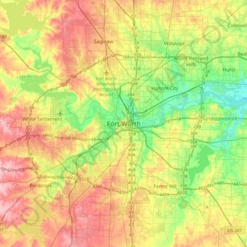
Nombre: Mapa topográfico Fort Worth, altitud, relieve.
Lugar: Fort Worth, Tarrant County, Texas, 76102, United States (32.59318 -97.49275 32.91318 -97.17275)
Altitud media: 202 m
Altitud mínima: 139 m
Altitud máxima: 279 m
Otros mapas topográficos
Haga clic en un mapa para ver su topografía, su altitud y su relieve.
Luther Lake
United States > Texas > Tarrant County > Fort Worth
Luther Lake, Fort Worth, Tarrant County, Texas, United States
Altitud media: 212 m