
Mapa topográfico Fox Creek
Mapa interactivo
Haga clic en el mapa para ver la altitud.
Acerca de este mapa
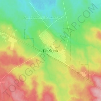
Nombre: Mapa topográfico Fox Creek, altitud, relieve.
Lugar: Fox Creek, Town of Fox Creek, Alberta, T0H 1P0, Canada (54.35721 -116.84338 54.43721 -116.76338)
Altitud media: 834 m
Altitud mínima: 776 m
Altitud máxima: 913 m
Fox Creek is a town in northwest Alberta, Canada. It is located on Highway 43, approximately 259 km (161 mi) northwest of Edmonton and 199 km (124 mi) southeast of Grande Prairie, and has an elevation of 808 m (2,651 ft).