
Mapa topográfico Kollam
Mapa interactivo
Haga clic en el mapa para ver la altitud.
Acerca de este mapa
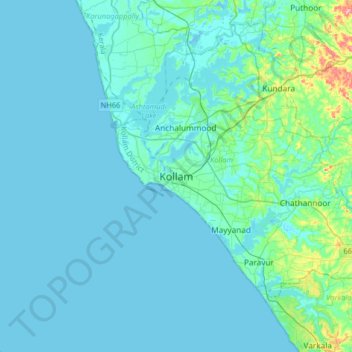
Nombre: Mapa topográfico Kollam, altitud, relieve.
Lugar: Kollam, Kerala, 691001, India (8.72795 76.43550 9.04795 76.75550)
Altitud media: 12 m
Altitud mínima: -2 m
Altitud máxima: 122 m
Along with (Muziris), Quilon was an ancient seaport on the Malabar Coast of India from the early centuries before the Christian era. The city had a high commercial reputation from the days of the Phoenicians and Ancient Romans. Pliny the Elder (23–79 AD) mentions Greek ships anchored at Muziris and Nelcynda. There was also a land route over the Western Ghats. Spices, pearls, diamonds, and silk were exported to Egypt and Rome from these ports. Pearls and diamonds came to the Chera Kingdom from Ceylon and the southeastern coast of India, then known as the Pandyan Kingdom. Cosmas Indicopleustes, a Greek Nestorian sailor, in his book the Christian Topography who visited the Malabar coast in 550, mentions an enclave of Christian believers in Male (Chera Kingdom). He writes, "In the island of Tabropane (Ceylon), there is a church of Christians, and clerics and faithful. Likewise at Male, where the pepper grows, and in the farming community of Kalliana (Kalliankal at Nillackal) there is also a bishop consecrated in Persia in accordance with the Nicea Sunnahadose of 325 AD." The Nestorian Patriarch Jesujabus, who died in 660 AD, mentions Kollam in his letter to Simon, Metropolitan of Persia.