
Haz una donación
Equípate para tu próxima aventura:
Como asociado de Amazon, este sitio gana comisiones por las compras que califican, sin ningún costo adicional para usted.
Mapa topográfico Watertown
Haga clic en el mapa para ver la altitud.
Haz una donación
Equípate para tu próxima aventura:
Como asociado de Amazon, este sitio gana comisiones por las compras que califican, sin ningún costo adicional para usted.
Watertown
Watertown is in southeastern Litchfield County and is bordered to the southeast by the city of Waterbury in New Haven County. Other bordering towns are Middlebury to the south, Woodbury and Bethlehem to the west, Morris to the northwest, and Thomaston to the east. It is in the Eastern Standard time zone. The elevation at the town center is 583 feet (178 m).
Haz una donación
Equípate para tu próxima aventura:
Como asociado de Amazon, este sitio gana comisiones por las compras que califican, sin ningún costo adicional para usted.
Acerca de este mapa
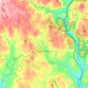
Nombre: Mapa topográfico Watertown, altitud, relieve.
Altitud media: 199 m
Altitud mínima: 75 m
Altitud máxima: 336 m
Haz una donación
Equípate para tu próxima aventura:
Como asociado de Amazon, este sitio gana comisiones por las compras que califican, sin ningún costo adicional para usted.
Otros mapas topográficos
Haga clic en un mapa para ver su topografía, su altitud y su relieve.
Huntington
United States > Connecticut > Naugatuck Valley Planning Region > Shelton
Altitud media: 111 m
Minortown
United States > Connecticut > Naugatuck Valley Planning Region > Woodbury
Altitud media: 169 m
White Hills
United States > Connecticut > Naugatuck Valley Planning Region > Shelton
Altitud media: 124 m
Haz una donación
Equípate para tu próxima aventura:
Como asociado de Amazon, este sitio gana comisiones por las compras que califican, sin ningún costo adicional para usted.
Mad River
United States > Connecticut > Naugatuck Valley Planning Region > Waterbury > Fair Lawn
Altitud media: 134 m
Traditions
United States > Connecticut > Naugatuck Valley Planning Region > Southbury > South Britain
Altitud media: 112 m
Fox Hollow
United States > Connecticut > Naugatuck Valley Planning Region > Cheshire
Altitud media: 64 m
Westview Heights
United States > Connecticut > Naugatuck Valley Planning Region > Middlebury
Altitud media: 159 m
Haz una donación
Equípate para tu próxima aventura:
Como asociado de Amazon, este sitio gana comisiones por las compras que califican, sin ningún costo adicional para usted.
Union City
United States > Connecticut > Naugatuck Valley Planning Region > Naugatuck
Altitud media: 124 m
Warsaw Park
United States > Connecticut > Naugatuck Valley Planning Region > Ansonia
Altitud media: 107 m
Bunker Hill
United States > Connecticut > Naugatuck Valley Planning Region > Waterbury
Altitud media: 140 m
Haz una donación
Equípate para tu próxima aventura:
Como asociado de Amazon, este sitio gana comisiones por las compras que califican, sin ningún costo adicional para usted.
Cedar Land
United States > Connecticut > Naugatuck Valley Planning Region > Southbury
Altitud media: 103 m
Town Plot Hill
United States > Connecticut > Naugatuck Valley Planning Region > Waterbury
Altitud media: 127 m
Millville
United States > Connecticut > Naugatuck Valley Planning Region > Naugatuck
Altitud media: 132 m
Bunker Hill
United States > Connecticut > Naugatuck Valley Planning Region > Waterbury
Altitud media: 140 m
Haz una donación
Equípate para tu próxima aventura:
Como asociado de Amazon, este sitio gana comisiones por las compras que califican, sin ningún costo adicional para usted.
Bunker Hill
United States > Connecticut > Naugatuck Valley Planning Region > Waterbury
Altitud media: 140 m
Minortown
United States > Connecticut > Naugatuck Valley Planning Region > Woodbury
Altitud media: 169 m
Gulls Hollow
United States > Connecticut > Naugatuck Valley Planning Region > Bethlehem
Altitud media: 243 m
Allentown
United States > Connecticut > Naugatuck Valley Planning Region > Plymouth
Altitud media: 244 m
Haz una donación
Equípate para tu próxima aventura:
Como asociado de Amazon, este sitio gana comisiones por las compras que califican, sin ningún costo adicional para usted.