
Mapa topográfico Sewa
Mapa interactivo
Haga clic en el mapa para ver la altitud.
Acerca de este mapa
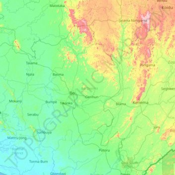
Nombre: Mapa topográfico Sewa, altitud, relieve.
Lugar: Sewa, Bo District, Southern Province, Sierra Leone (7.30751 -12.13816 8.69962 -11.25444)
Altitud media: 149 m
Altitud mínima: 0 m
Altitud máxima: 819 m
Otros mapas topográficos
Haga clic en un mapa para ver su topografía, su altitud y su relieve.
Sherbro Island
Sierra Leone > Southern Province
Sherbro Island, Bonthe District, Southern Province, Sierra Leone
Altitud media: 3 m
Selu
Sierra Leone > Southern Province > Selu
Selu, Bo District, Southern Province, Sierra Leone
Altitud media: 237 m
Bonthe
Sierra Leone > Southern Province > Bonthe
Bonthe, Bonthe District, Southern Province, Sierra Leone
Altitud media: 2 m