
Mapa topográfico Bude
Mapa interactivo
Haga clic en el mapa para ver la altitud.
Acerca de este mapa
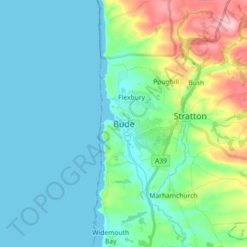
Nombre: Mapa topográfico Bude, altitud, relieve.
Lugar: Bude, Cornwall, England, EX23 8LD, United Kingdom (50.78853 -4.58694 50.86853 -4.50694)
Altitud media: 39 m
Altitud mínima: 0 m
Altitud máxima: 181 m
Its earlier importance was as a harbour, and then a source of sea sand useful for improving the inland soil. This was transported on the Bude Canal. The Victorians favoured it as a seaside resort. With new rail links, it became a popular seaside destination in the 20th century. Bradshaw's Guide of 1866, Section 2, described Bude as: "a small port and picturesque village in the north-eastern extremity of Cornwall". It described the town as having the dignity of a fashionable marine resort with excellent facilities for bathers. The harbour bed consists of fine bright yellow sand consisting of small shells. "The sea view is of a striking, bold and sublime description – the rocks rising on every side to lofty broken elevations". It also describes Bude as a romantic retreat.
Otros mapas topográficos
Haga clic en un mapa para ver su topografía, su altitud y su relieve.
Camborne
United Kingdom > England > Cornwall
Camborne, Cornwall, England, United Kingdom
Altitud media: 104 m
Gorran Haven
United Kingdom > England > Cornwall
Gorran Haven, Cornwall, England, PL26 6PA, United Kingdom
Altitud media: 39 m
Trevalga
United Kingdom > England > Cornwall
Trevalga, Cornwall, England, United Kingdom
Altitud media: 138 m
Seaview Terrace
United Kingdom > England > Cornwall
Seaview Terrace, St. Enoder, Cornwall, England, TR8 5UE, United Kingdom
Altitud media: 111 m
St. Dennis
United Kingdom > England > Cornwall
St. Dennis, Cornwall, England, United Kingdom
Altitud media: 160 m
Camelford
United Kingdom > England > Cornwall > Camelford
Camelford, Cornwall, England, United Kingdom
Altitud media: 203 m