
Haz una donación
Equípate para tu próxima aventura:
Como asociado de Amazon, este sitio gana comisiones por las compras que califican, sin ningún costo adicional para usted.
Mapa topográfico Umlazi
Haga clic en el mapa para ver la altitud.
Haz una donación
Equípate para tu próxima aventura:
Como asociado de Amazon, este sitio gana comisiones por las compras que califican, sin ningún costo adicional para usted.
Umlazi
Umlazi is approximately 15 kilometres (9 mi) south-west of the Durban CBD, between the uMlaza River to the north and eZimbokodweni River to the south, with the smaller Siphingo River flowing in the southern parts of the township. It lies at an average altitude of approximately 101 m (331 ft) above sea level in the hills south-east of Durban.
Haz una donación
Equípate para tu próxima aventura:
Como asociado de Amazon, este sitio gana comisiones por las compras que califican, sin ningún costo adicional para usted.
Acerca de este mapa
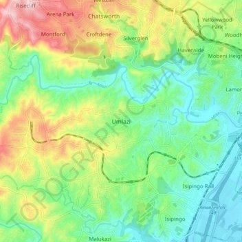
Nombre: Mapa topográfico Umlazi, altitud, relieve.
Altitud media: 100 m
Altitud mínima: 3 m
Altitud máxima: 284 m
Haz una donación
Equípate para tu próxima aventura:
Como asociado de Amazon, este sitio gana comisiones por las compras que califican, sin ningún costo adicional para usted.
Otros mapas topográficos
Haga clic en un mapa para ver su topografía, su altitud y su relieve.
Umgeni River
South Africa > KwaZulu-Natal > eThekwini Metropolitan Municipality > Queensburgh
Altitud media: 131 m
Pigeon Valley
South Africa > KwaZulu-Natal > eThekwini Metropolitan Municipality > Durban
Altitud media: 69 m
Haz una donación
Equípate para tu próxima aventura:
Como asociado de Amazon, este sitio gana comisiones por las compras que califican, sin ningún costo adicional para usted.
Molweni River
South Africa > KwaZulu-Natal > eThekwini Metropolitan Municipality > Forest Hills
Altitud media: 227 m
Umbilo River
South Africa > KwaZulu-Natal > eThekwini Metropolitan Municipality > Durban
Altitud media: 56 m
Bluff Nature Reserve
South Africa > KwaZulu-Natal > eThekwini Metropolitan Municipality > Durban
Altitud media: 38 m
Haz una donación
Equípate para tu próxima aventura:
Como asociado de Amazon, este sitio gana comisiones por las compras que califican, sin ningún costo adicional para usted.
Umhlanga River
South Africa > KwaZulu-Natal > eThekwini Metropolitan Municipality > Phoenix
Altitud media: 130 m
Umbilo River
South Africa > KwaZulu-Natal > eThekwini Metropolitan Municipality > Pinetown
Altitud media: 337 m
Palmiet River
South Africa > KwaZulu-Natal > eThekwini Metropolitan Municipality > Pinetown
Altitud media: 308 m
Haz una donación
Equípate para tu próxima aventura:
Como asociado de Amazon, este sitio gana comisiones por las compras que califican, sin ningún costo adicional para usted.
Umgeni River
South Africa > KwaZulu-Natal > eThekwini Metropolitan Municipality > Queensburgh
Altitud media: 131 m
eThekwini Ward 32
South Africa > KwaZulu-Natal > eThekwini Metropolitan Municipality
Altitud media: 25 m
Haz una donación
Equípate para tu próxima aventura:
Como asociado de Amazon, este sitio gana comisiones por las compras que califican, sin ningún costo adicional para usted.
Umbilo River
South Africa > KwaZulu-Natal > eThekwini Metropolitan Municipality > Durban
Altitud media: 56 m
Plantations
South Africa > KwaZulu-Natal > eThekwini Metropolitan Municipality > Hillcrest
Altitud media: 631 m