
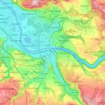
Mapa topográfico Pirna
Mapa interactivo
Haga clic en el mapa para ver la altitud.
Acerca de este mapa
Nombre: Mapa topográfico Pirna, altitud, relieve.
Altitud media: 199 m
Altitud mínima: 109 m
Altitud máxima: 356 m
Otros mapas topográficos
Haga clic en un mapa para ver su topografía, su altitud y su relieve.
Kleiner Sandberg
Germany > Saxony > Sächsische Schweiz-Osterzgebirge > Lohmen
Kleiner Sandberg, Lohmen, Lohmen/Stadt Wehlen, Sächsische Schweiz-Osterzgebirge, Saxony, 01829, Germany
Altitud media: 266 m
Rathen
Germany > Saxony > Sächsische Schweiz-Osterzgebirge
Rathen, Königstein/Sächs. Schw., Sächsische Schweiz-Osterzgebirge, Saxony, Germany
Altitud media: 194 m
Malter
Germany > Saxony > Sächsische Schweiz-Osterzgebirge > Dippoldiswalde
Malter, Dippoldiswalde, Sächsische Schweiz-Osterzgebirge, Saxony, 01734, Germany
Altitud media: 371 m
Lohmen
Germany > Saxony > Sächsische Schweiz-Osterzgebirge > Lohmen
Lohmen, Lohmen/Stadt Wehlen, Sächsische Schweiz-Osterzgebirge, Saxony, 01847, Germany
Altitud media: 226 m
Siamesische Zwillinge, Dick
Germany > Saxony > Sächsische Schweiz-Osterzgebirge > Bad Schandau
Siamesische Zwillinge, Dick, Bad Schandau, Sächsische Schweiz-Osterzgebirge, Saxony, Germany
Altitud media: 366 m
Bad Schandau
Germany > Saxony > Sächsische Schweiz-Osterzgebirge > Bad Schandau
Bad Schandau, Sächsische Schweiz-Osterzgebirge, Saxony, 01814, Germany
Altitud media: 301 m
Altenberg
Germany > Saxony > Sächsische Schweiz-Osterzgebirge
Altenberg, Sächsische Schweiz-Osterzgebirge, Saxony, Germany
Altitud media: 655 m
Mandarin
Germany > Saxony > Sächsische Schweiz-Osterzgebirge > Rosenthal-Bielatal
Mandarin, Rosenthal-Bielatal, Königstein/Sächs. Schw., Sächsische Schweiz-Osterzgebirge, Saxony, Germany
Altitud media: 428 m