
Mapa topográfico Chertsey
Haga clic en el mapa para ver la altitud.
Chertsey
Samuel Lewis devotes one of his longest entries to the small town in his 1848 topographical guide to England.
Acerca de este mapa
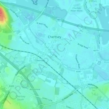
Nombre: Mapa topográfico Chertsey, altitud, relieve.
Altitud media: 17 m
Altitud mínima: 9 m
Altitud máxima: 66 m
Otros mapas topográficos
Haga clic en un mapa para ver su topografía, su altitud y su relieve.
Cooper's Hill Slopes
United Kingdom > England > Surrey > Borough of Runnymede > Englefield Green
Altitud media: 38 m
Chertsey
United Kingdom > England > Surrey > Borough of Runnymede
Samuel Lewis devotes one of his longest entries to the small town in his 1848 topographical guide to England.
Altitud media: 22 m
Egham Wick
United Kingdom > England > Surrey > Borough of Runnymede > Englefield Green
Altitud media: 55 m
Chertsey
United Kingdom > England > Surrey > Borough of Runnymede
Samuel Lewis devotes one of his longest entries to the small town in his 1848 topographical guide to England.
Altitud media: 22 m