
Mapa topográfico Yantai
Mapa interactivo
Haga clic en el mapa para ver la altitud.
Acerca de este mapa
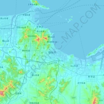
Nombre: Mapa topográfico Yantai, altitud, relieve.
Altitud media: 34 m
Altitud mínima: -3 m
Altitud máxima: 546 m
Yantai is located along the north coast of the Shandong Peninsula, south of the junction of Bohai Sea and Yellow Sea and parallel to the southern coast of Liaoning. The topographical breakdown consists of:
Otros mapas topográficos
Haga clic en un mapa para ver su topografía, su altitud y su relieve.