
Haz una donación
Equípate para tu próxima aventura:
Como asociado de Amazon, este sitio gana comisiones por las compras que califican, sin ningún costo adicional para usted.
Mapa topográfico Aguascalientes
Haga clic en el mapa para ver la altitud.
Haz una donación
Equípate para tu próxima aventura:
Como asociado de Amazon, este sitio gana comisiones por las compras que califican, sin ningún costo adicional para usted.
Aguascalientes
Aguascalientes (Spanish pronunciation: [ˌaɣwaskaˈljentes] ; lit. 'Hot Springs'), officially the Free and Sovereign State of Aguascalientes (Spanish: Estado Libre y Soberano de Aguascalientes), is one of the 32 states which comprise the Federal Entities of Mexico. At 22°N and with an average altitude of 1,950 m (6,400 ft) above sea level it is predominantly of semi-arid climate (Bhs and Bhk). The state is located in west-central Mexico and is located in the northern part of the Bajío region, which is in the north-central part of the country, bordered by Zacatecas to the north, east and west, and by Jalisco to the south.
Haz una donación
Equípate para tu próxima aventura:
Como asociado de Amazon, este sitio gana comisiones por las compras que califican, sin ningún costo adicional para usted.
Acerca de este mapa
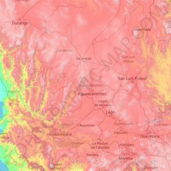
Nombre: Mapa topográfico Aguascalientes, altitud, relieve.
Lugar: Aguascalientes, Mexico (19.40000 -105.10000 24.60000 -99.90000)
Altitud media: 1.814 m
Altitud mínima: 0 m
Altitud máxima: 3.767 m
Haz una donación
Equípate para tu próxima aventura:
Como asociado de Amazon, este sitio gana comisiones por las compras que califican, sin ningún costo adicional para usted.
Otros mapas topográficos
Haga clic en un mapa para ver su topografía, su altitud y su relieve.
Mexico City
Mexico City is situated in the Valley of Mexico, an expansive highland region characterized by a unique and varied topography. The city itself rests at an elevation of approximately 7,350 feet (2,240 meters) above sea level, surrounded by formidable mountain ranges, including the Sierra de Guadalupe to the…
Altitud media: 2.619 m
Puebla
Most of its mountains belong to the Sierra Madre Oriental and the Trans-Mexican Volcanic Belt. The first is locally called the Sierra Norte del Puebla, entering the state from the northwest and then breaks up into the smaller chains of Sierra de Zacapoaxtla, Sierra de Huauchinango, Sierra de Teziutlán, Sierra…
Altitud media: 1.532 m
Baja California
Baja California is the 12th-largest state by area in Mexico. Its geography ranges from beaches to forests and deserts. The backbone of the state is the Sierra de Baja California, where Picacho del Diablo, the highest point of the peninsula, is located. This mountain range effectively divides the weather…
Altitud media: 179 m
Haz una donación
Equípate para tu próxima aventura:
Como asociado de Amazon, este sitio gana comisiones por las compras que califican, sin ningún costo adicional para usted.
Mérida
Mérida is located in the northwest part of the state of Yucatán, which occupies the northern portion of the Yucatán Peninsula. To the east is the state of Quintana Roo, to the west is the state of Campeche, to the north is the Gulf of Mexico, and far to the south is the state of Chiapas. The city is also…
Altitud media: 8 m
Chihuahua
The main mountain range in the state is the Sierra Madre Occidental reaching a maximum altitude of 10,826 ft (3,300 m) known as Cerro Mohinora. Mountains account for one third of the state's surface area which include large coniferous forests. The climate in the mountainous regions varies. Chihuahua has more…
Altitud media: 1.397 m
Oaxaca
The state is in the south of Mexico, bordered by the states of Puebla, Veracruz, Chiapas and Guerrero, with the Pacific Ocean to the south. It has a territory of 93,967 km2 (36,281 sq mi), accounting for less than 5% of Mexico's territory. Here several mountain chains come together, with the elevation varying…
Altitud media: 714 m
Haz una donación
Equípate para tu próxima aventura:
Como asociado de Amazon, este sitio gana comisiones por las compras que califican, sin ningún costo adicional para usted.
Mexico City
Mexico City (Spanish: Ciudad de México, locally [sjuˈða(ð) ðe ˈmexiko] (listen); abbr.: CDMX; Nahuatl: Altepetl Mexico) is the capital and largest city of Mexico, and the most populous city in North America. One of the world's alpha cities, it is located in the Valley of Mexico within the high Mexican…
Altitud media: 2.619 m
Yucatán
The State of Yucatán is located on the Yucatán Peninsula. It borders the states of Campeche to the southwest, Quintana Roo to the east and southeast, and the Gulf of Mexico to the north and west. As a whole, the state is extremely flat with little or no topographic variation, with the exception of the Puuc…
Altitud media: 16 m
Oaxaca
The state is located in the south of Mexico, bordered by the states of Puebla, Veracruz, Chiapas and Guerrero with the Pacific Ocean to the south. It has a territory of 93,967 km2 (36,281 sq mi), accounting for less than 5% of Mexico's territory. Here several mountain chains come together, with the elevation…
Altitud media: 714 m
Haz una donación
Equípate para tu próxima aventura:
Como asociado de Amazon, este sitio gana comisiones por las compras que califican, sin ningún costo adicional para usted.
Chiapas
The Sierra Madre de Chiapas runs parallel to the Pacific coastline of the state, northwest to southeast as a continuation of the Sierra Madre del Sur. This area has the highest altitudes in Chiapas including the Tacaná Volcano, which rises 4,093 m (13,428 ft) above sea level. Most of these mountains are…
Altitud media: 645 m
Guanajuato
Guanajuato is in the center of Mexico, northwest of Mexico City, bordering Zacatecas, San Luis Potosí, Michoacán, Querétaro, and Jalisco. It is the 20th-largest of Mexico's states, with an area of 30,589 km². It has an average altitude of 2,015 meters (6,611 ft) above sea level, with its territory divided…
Altitud media: 2.005 m
Guerrero
The state's climate is dominated by the rainy tropical areas and rainy temperate areas. The former has high temperatures above 18 °C (64.4 °F) year round and experiences most rain in the summer and early fall. Most of this is found near the coast under 2,000 m (6,562 ft) asl. In the higher elevations away…
Altitud media: 862 m
Haz una donación
Equípate para tu próxima aventura:
Como asociado de Amazon, este sitio gana comisiones por las compras que califican, sin ningún costo adicional para usted.
Michoacán
Much of the climate of the state is determined by altitude and other geographical features. Average temperatures vary from 13 °C (55 °F) to 29 °C (84 °F). Lower temperatures correspond with the highland areas in the north and east while the lower south and west, called La Costa (the coast) or Tierra…
Altitud media: 1.239 m
Chiapas
The Sierra Madre de Chiapas runs parallel to the Pacific coastline of the state, northwest to southeast as a continuation of the Sierra Madre del Sur. This area has the highest altitudes in Chiapas including the Tacaná Volcano, which rises 4,093 m (13,428 ft) above sea level. Most of these mountains are…
Altitud media: 645 m
Haz una donación
Equípate para tu próxima aventura:
Como asociado de Amazon, este sitio gana comisiones por las compras que califican, sin ningún costo adicional para usted.
Puebla
Most of the mountains of Puebla belong to the Sierra Madre Oriental and the Trans-Mexican Volcanic Belt. The first is locally called the Sierra Norte del Puebla, entering the state from the northwest and then breaks up into the smaller chains of Sierra de Zacapoaxtla, Sierra de Huauchinango, Sierra de…
Altitud media: 1.532 m
Veracruz
The natural geography can be categorized into nine regions: The Sierra de Zongolica, the Tecolutla Region, the Huayacocotla Region, the Metlac River area, the Tuxtlas Region, the Central Region, the Laguna del Castillo Region, the Pueblo Viejo-Tamiahua Region and the Laguna de Alvarado Region. The topography…
Altitud media: 653 m
Haz una donación
Equípate para tu próxima aventura:
Como asociado de Amazon, este sitio gana comisiones por las compras que califican, sin ningún costo adicional para usted.
Jalisco
Jalisco is made up of a diverse terrain that includes forests, beaches, plains, and lakes. Altitudes in the state vary from 0 to 4,300 meters (0 to 14,110 ft) above sea level, from the coast to the top of the Nevado de Colima. The Jalisco area contains all five of Mexico's natural ecosystems: arid and semi…
Altitud media: 1.301 m
Puebla
Most of its mountains belong to the Sierra Madre Oriental and the Trans-Mexican Volcanic Belt. The first is locally called the Sierra Norte del Puebla, entering the state from the northwest and then breaks up into the smaller chains of Sierra de Zacapoaxtla, Sierra de Huauchinango, Sierra de Teziutlán, Sierra…
Altitud media: 1.532 m
Tulum
Like most of the Yucatan Peninsula Tulum is entirely flat with a gentle slope towards the sea, so from west to east, the area never reaches an altitude higher than 25 metres (82 ft) above sea level. The municipality is 5 metres (16 ft) above sea level on average.
Altitud media: 10 m
Haz una donación
Equípate para tu próxima aventura:
Como asociado de Amazon, este sitio gana comisiones por las compras que califican, sin ningún costo adicional para usted.
Querétaro
Three of Mexico’s geographic zones cover parts of the state. The Mesa del Centro is in the center-west of the state, and mostly consists of small mesas with an average altitude of 2,000 meters (6,562 feet) above sea level (ASL). A few elevations reach over 3,000 meters (9,843 feet). The Sierra Madre Oriental…
Altitud media: 1.988 m
Nuevo León
Nuevo León's geography is known for englobing three of the most important physiographic provinces of the northeast region. The south end of the Great Plains is considered to start in the northernmost regions of Nuevo León. The region is characterized by the soft hills that dominates the lands neighboring the…
Altitud media: 805 m
Haz una donación
Equípate para tu próxima aventura:
Como asociado de Amazon, este sitio gana comisiones por las compras que califican, sin ningún costo adicional para usted.
Querétaro
Three of Mexico’s geographic zones cover parts of the state. The Mesa del Centro is in the center-west of the state, and mostly consists of small mesas with an average altitude of 2,000 meters (6,562 feet) above sea level (ASL). A few elevations reach over 3,000 meters (9,843 feet). The Sierra Madre Oriental…
Altitud media: 1.988 m
San Luis Potosí
The mean elevation is about 6,000 ft ensuring a temperate climate for the most part. The state lies partly within the arid zone of the north, while the southern half receiving more rainfall through the influence of the Nortes, which deliver significant amounts of rain. The rainfall, however, is uncertain at…
Altitud media: 1.510 m
Baja California
Baja California is the 12th-largest state by area in Mexico. Its geography ranges from beaches to forests and deserts. The backbone of the state is the Sierra de Baja California, where Picacho del Diablo, the highest point of the peninsula, is located. This mountain range effectively divides the weather…
Altitud media: 179 m
Haz una donación
Equípate para tu próxima aventura:
Como asociado de Amazon, este sitio gana comisiones por las compras que califican, sin ningún costo adicional para usted.
Hidalgo
There are three main climates in the state. The lowlands are hot with temperatures rising as high as 44C in the summer in places such as the municipality of Pisaflores. Temperate regions can have hot days but often the temperature is moderated by cooler winds and clouds. Cold climates dominate the highest…
Altitud media: 1.774 m
Zacatecas
The state has an average altitude of 2230 meters above sea level, with the capital at 2,496 masl. The state has three main geographical regions, the Sierra Madre Occidental in the west, the Mexican Plateau and the Sierra Madre Oriental. Most of it is in the Sierra Madre Occidental with highly rugged peaks of…
Altitud media: 1.875 m
Oaxaca
The state is located in the south of Mexico, bordered by the states of Puebla, Veracruz, Chiapas and Guerrero with the Pacific Ocean to the south. It has a territory of 93,967 km2 (36,281 sq mi), accounting for less than 5% of Mexico's territory. Here several mountain chains come together, with the elevation…
Altitud media: 714 m
Cozumel
Large parts of the island are covered with mangrove forest which has many endemic animal species. Cozumel is a flat island based on limestone, resulting in a karst topography. The highest natural point on the island is less than 15 m (49 ft) above sea level. The cenotes are deep water-filled sinkholes formed…
Altitud media: 1 m
Haz una donación
Equípate para tu próxima aventura:
Como asociado de Amazon, este sitio gana comisiones por las compras que califican, sin ningún costo adicional para usted.
Guadalajara
Under the Köppen climate classification, Guadalajara has a humid subtropical climate (Cwa) that is quite close to a tropical climate, featuring dry, warm winters and hot, wet summers. Guadalajara's climate is influenced by its high altitude and the general seasonality of precipitation patterns in western…
Altitud media: 1.543 m
Durango
The area of Durango is 123,451.2 km2 or 12.3 million ha; this accounts for about 6.3% of the entire territory of Mexico. It is the fourth largest state, lying at the extreme northwest of the Central Mexican Plateau, where it meets the Sierra Madre Occidental—the highest peaks in the state. The state has an…
Altitud media: 1.580 m
Mexico City
Mexico City (Spanish: Ciudad de México, locally [sjuˈða(ð) ðe ˈmexiko] ; abbr.: CDMX; Nahuatl: Āltepētl Mēxihco, Nahuatl pronunciation: [aːl'tepeːt͡ɬ meːˈʃiʔko]; Otomi: 'Monda) is the capital and largest city of Mexico, and the most populous city in North America. Mexico City is one of the…
Altitud media: 2.619 m
Querétaro
Mexico > Querétaro > Municipio de Querétaro
The municipality has rolling hills, mountain ranges and flatlands. Most of the rolling hills cross the territory from south to north, paralleling the Querétaro-San Luis Potosí highway. Most plains are located in the north, and are of sedimentary soil with some protrusions of volcanic rock. Altitude varies…
Altitud media: 1.921 m
Haz una donación
Equípate para tu próxima aventura:
Como asociado de Amazon, este sitio gana comisiones por las compras que califican, sin ningún costo adicional para usted.
Yucatán
The topography of the Yucatán Peninsula is characterized by a largely flat and low-lying terrain, primarily formed from limestone and covered by a thin layer of soil. This flatness is a defining feature, as the peninsula is part of the larger Yucatán Platform, which extends across approximately 70,000 square…
Altitud media: 16 m
Metepec
Metepec (Spanish: [meteˈpek] ) is a municipality in the State of Mexico in Mexico and is located directly to the east of the state capital, Toluca, at an altitude of 2,635 metres (8,645 ft) above sea level. The center of Mexico City lies some 50 km further to the east. The city of Metepec also form part of…
Altitud media: 2.625 m
Haz una donación
Equípate para tu próxima aventura:
Como asociado de Amazon, este sitio gana comisiones por las compras que califican, sin ningún costo adicional para usted.
Sonora
Sonora's natural geography is divided into three parts: the Sierra Madre Occidental in the east of the state; plains and rolling hills in the center; and the coast on the Gulf of California. It is primarily arid or semiarid deserts and grasslands, with only the highest elevations having sufficient rainfall to…
Altitud media: 761 m
Mexico City
The majority of Mexican central and northern territories are located at high altitudes, and as such the highest elevations are found at the Trans-Mexican Volcanic Belt which crosses Mexico east to west: Pico de Orizaba (5,700 m or 18,701 ft), Popocatépetl (5,462 m or 17,920 ft) and Iztaccihuatl (5,286 m or…
Altitud media: 2.344 m
Haz una donación
Equípate para tu próxima aventura:
Como asociado de Amazon, este sitio gana comisiones por las compras que califican, sin ningún costo adicional para usted.
Haz una donación
Equípate para tu próxima aventura:
Como asociado de Amazon, este sitio gana comisiones por las compras que califican, sin ningún costo adicional para usted.
Baja California Sur
The climate of the state is dry, with an average annual temperature of 18–22 °C and average annual rainfall of less than 200mm. The lower elevations are the driest and hottest, with summer daytime temperatures above 40 °C; wintertime temperatures may fall below freezing. The exception to desert conditions…
Altitud media: 90 m
Huejotzingo
Huejotzingo is located on the slopes of the Sierra Nevada, 25 km northwest from the capital on Highway 150. The geography of the land varies depending on the proximity to the Sierra Nevada. Areas at altitudes under 2,500 masl on the far east side are part of the Valley of Puebla, more specifically the plains…
Altitud media: 2.436 m
Haz una donación
Equípate para tu próxima aventura:
Como asociado de Amazon, este sitio gana comisiones por las compras que califican, sin ningún costo adicional para usted.
Yucatán
The State of Yucatán is located on the Yucatán Peninsula. It borders the states of Campeche to the southwest, Quintana Roo to the east and southeast, and the Gulf of Mexico to the north and west. As a whole, the state is extremely flat with little or no topographic variation, with the exception of the Puuc…
Altitud media: 16 m
Haz una donación
Equípate para tu próxima aventura:
Como asociado de Amazon, este sitio gana comisiones por las compras que califican, sin ningún costo adicional para usted.
Morelos
Morelos, most of which is between 1,000 and 3,300 meters (2,900–9,800 feet) above sea level, has a very diverse topography: 42% is mountainous, 16% hilly land, and 42% flat terrain. The highest altitudes are found near the state's border with Mexico City, and the lowest are found in the Huaxtla region. The…
Altitud media: 1.642 m
Haz una donación
Equípate para tu próxima aventura:
Como asociado de Amazon, este sitio gana comisiones por las compras que califican, sin ningún costo adicional para usted.
Sonora
Sonora's natural geography is divided into three parts: the Sierra Madre Occidental in the east of the state; plains and rolling hills in the center; and the coast on the Gulf of California. It is primarily arid or semiarid deserts and grasslands, with only the highest elevations having sufficient rainfall to…
Altitud media: 761 m
State of Mexico
About seventy percent of the state has a temperate moist climate, which consists of the highlands of the Toluca Valley and the areas around Texcoco in the north, the Toluca Valley and the areas around Texcoco. Average year-round temperature varies between 12C and 18C with annual precipitation above 700…
Altitud media: 2.059 m
Haz una donación
Equípate para tu próxima aventura:
Como asociado de Amazon, este sitio gana comisiones por las compras que califican, sin ningún costo adicional para usted.
Sinaloa
Sinaloa has a warm climate on the coast; moderately warm climate in the valleys and foothills; moderately cold in the lower mountains, and cold in the higher elevations. Its weather characteristics vary from subtropical and tropical, found on coastal plains, to cold in the nearby mountains. Temperatures range…
Altitud media: 749 m
Bustamante
Bustamante is located in an irrigated valley at the mouth of a well-watered canyon in the headwaters of the Sabinas River, a tributary of the Salado River. The Sierra de Gomas to the west of the town rise to an elevation of 5,591 feet (1,704 m) at the Cabeza de Leon four miles south-southwest of Bustamante.…
Altitud media: 624 m
Haz una donación
Equípate para tu próxima aventura:
Como asociado de Amazon, este sitio gana comisiones por las compras que califican, sin ningún costo adicional para usted.
Juanacatlán
The municipio of Juanacatlán in the east-central part of the state, between 20º24’00’’ and 20º32’15’’ northern latitude and between 103º03’10’’ and 103º15’00’’ west latitude, at an altitude of 1,530m.
Altitud media: 1.585 m
Baja California
Baja California is the 12th-largest state by area in Mexico. Its geography ranges from beaches to forests and deserts. The backbone of the state is the Sierra de Baja California, where Picacho del Diablo, the highest point of the peninsula, is located. This mountain range effectively divides the weather…
Altitud media: 179 m
Haz una donación
Equípate para tu próxima aventura:
Como asociado de Amazon, este sitio gana comisiones por las compras que califican, sin ningún costo adicional para usted.
Baja California Sur
The climate of the state is dry, with an average annual temperature of 18–22 °C and average annual rainfall of less than 200mm. The lower elevations are the driest and hottest, with summer daytime temperatures above 40 °C; wintertime temperatures may fall below freezing. The exception to desert conditions…
Altitud media: 90 m
Monterrey
The city of Monterrey is 540 metres (1,770 ft) above sea level in the northeastern state of Nuevo León. Monterrey translated from Spanish to English is "King Mount" or "King mountain", which refers to the city's topography and the large mountains that surround it. The Santa Catarina River—dry most of the…
Altitud media: 861 m
State of Mexico
About seventy percent of the state has a temperate moist climate, which consists of the highlands of the Toluca Valley and the areas around Texcoco in the north, the Toluca Valley and the areas around Texcoco. Average year-round temperature varies between 12C and 18C with annual precipitation above 700…
Altitud media: 2.059 m
Haz una donación
Equípate para tu próxima aventura:
Como asociado de Amazon, este sitio gana comisiones por las compras que califican, sin ningún costo adicional para usted.
Puebla
Most of the mountains of Puebla belong to the Sierra Madre Oriental and the Trans-Mexican Volcanic Belt. The first is locally called the Sierra Norte del Puebla, entering the state from the northwest and then breaks up into the smaller chains of Sierra de Zacapoaxtla, Sierra de Huauchinango, Sierra de…
Altitud media: 1.532 m
Haz una donación
Equípate para tu próxima aventura:
Como asociado de Amazon, este sitio gana comisiones por las compras que califican, sin ningún costo adicional para usted.
Nayarit
Nayarit's natural vegetation varies with altitude; coastal lowlands and river valleys were, historically, covered with tropical dry forest, containing many native deciduous trees that lost their leaves during the dry seasons. The Sinaloan dry forests now cover the northern coastal lowlands, and extend up the…
Altitud media: 834 m
Haz una donación
Equípate para tu próxima aventura:
Como asociado de Amazon, este sitio gana comisiones por las compras que califican, sin ningún costo adicional para usted.
Charcas
Charcas is a town and municipality in the Mexican state of San Luis Potosí. The municipality covers an area of 4.911 km2. As of 2020, the municipality had a total population of 14,117 people. Charcas is just south of the Tropic of Cancer. Due to its elevation of 2,219 metres (7,280 ft), the climate is mild.
Altitud media: 2.119 m
Haz una donación
Equípate para tu próxima aventura:
Como asociado de Amazon, este sitio gana comisiones por las compras que califican, sin ningún costo adicional para usted.
Baja California
Baja California is the 12th-largest state by area in Mexico. Its geography ranges from beaches to forests and deserts. The backbone of the state is the Sierra de Baja California, where Picacho del Diablo, the highest point of the peninsula, is located. This mountain range effectively divides the weather…
Altitud media: 179 m
Jalisco
Jalisco is made up of a diverse terrain that includes forests, beaches, plains, and lakes. Altitudes in the state vary from 0 to 4,300 meters (0 to 14,110 ft) above sea level, from the coast to the top of the Nevado de Colima. The Jalisco area contains all five of Mexico's natural ecosystems: arid and semi…
Altitud media: 1.301 m
Veracruz
The natural geography can be categorized into nine regions: The Sierra de Zongolica, the Tecolutla Region, the Huayacocotla Region, the Metlac River area, the Tuxtlas Region, the Central Region, the Laguna del Castillo Region, the Pueblo Viejo-Tamiahua Region and the Laguna de Alvarado Region. The topography…
Altitud media: 653 m
Haz una donación
Equípate para tu próxima aventura:
Como asociado de Amazon, este sitio gana comisiones por las compras que califican, sin ningún costo adicional para usted.