
Haz una donación
Equípate para tu próxima aventura:
Como asociado de Amazon, este sitio gana comisiones por las compras que califican, sin ningún costo adicional para usted.
Mapa topográfico Isabel Lake
Haga clic en el mapa para ver la altitud.
Haz una donación
Equípate para tu próxima aventura:
Como asociado de Amazon, este sitio gana comisiones por las compras que califican, sin ningún costo adicional para usted.
Acerca de este mapa
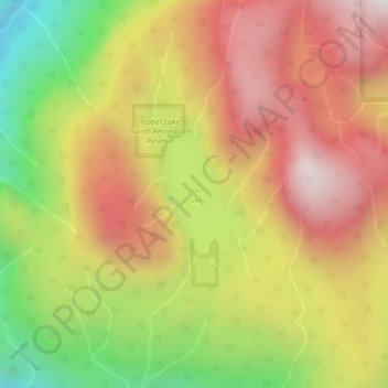
Nombre: Mapa topográfico Isabel Lake, altitud, relieve.
Altitud media: 687 m
Altitud mínima: 49 m
Altitud máxima: 1.209 m
Haz una donación
Equípate para tu próxima aventura:
Como asociado de Amazon, este sitio gana comisiones por las compras que califican, sin ningún costo adicional para usted.
Otros mapas topográficos
Haga clic en un mapa para ver su topografía, su altitud y su relieve.
Pattinson Peak
Canada > British Columbia > Fraser Valley Regional District > Area F (McConnell Creek/Hatzic Prairie)
Altitud media: 762 m
Mount Garibaldi
Canada > British Columbia > Fraser Valley Regional District > Area F (McConnell Creek/Hatzic Prairie)
Mount Garibaldi (Squamish: Nch'ḵay̓, pronounced [n̩.ʧʼqɛˀj̰]) is a dormant stratovolcano in the Garibaldi Ranges of the Pacific Ranges in southwestern British Columbia, Canada. It has a maximum elevation of 2,678 metres (8,786 feet) and rises above the surrounding landscape on the east side of the…
Altitud media: 2.146 m
Mamquam Icefield
Canada > British Columbia > Fraser Valley Regional District > Area F (McConnell Creek/Hatzic Prairie)
Altitud media: 1.925 m
Mount Garibaldi
Canada > British Columbia > Fraser Valley Regional District > Area F (McConnell Creek/Hatzic Prairie)
Mount Garibaldi (Squamish: Nch'ḵay̓, pronounced [n̩.ʧʼqɛˀj̰]) is a dormant stratovolcano in the Garibaldi Ranges of the Pacific Ranges in southwestern British Columbia, Canada. It has a maximum elevation of 2,678 metres (8,786 feet) and rises above the surrounding landscape on the east side of the…
Altitud media: 2.146 m
Haz una donación
Equípate para tu próxima aventura:
Como asociado de Amazon, este sitio gana comisiones por las compras que califican, sin ningún costo adicional para usted.
Mount Garibaldi
Canada > British Columbia > Fraser Valley Regional District > Area F (McConnell Creek/Hatzic Prairie)
Mount Garibaldi (Squamish: Nch'ḵay̓, pronounced [n̩.ʧʼqɛˀj̰]) is a dormant stratovolcano in the Garibaldi Ranges of the Pacific Ranges in southwestern British Columbia, Canada. It has a maximum elevation of 2,678 metres (8,786 feet) and rises above the surrounding landscape on the east side of the…
Altitud media: 2.146 m