
Haz una donación
Equípate para tu próxima aventura:
Como asociado de Amazon, este sitio gana comisiones por las compras que califican, sin ningún costo adicional para usted.
Mapa topográfico Hasliberg
Haga clic en el mapa para ver la altitud.
Haz una donación
Equípate para tu próxima aventura:
Como asociado de Amazon, este sitio gana comisiones por las compras que califican, sin ningún costo adicional para usted.
Hasliberg
The main inhabited area of Hasliberg is situated on a south-west facing terrace above the valley of the river Aare, at an approximate altitude of 1,000 m (3,300 ft). Spread out along this terrace are the villages of Hohfluh, Wasserwendi, Goldern and Reuti. To the north and east the municipality spreads out onto higher ground, reaching its highest points at the summits of Glogghüs at 2,534 m (8,314 ft), and Planplatten at 2,245 m (7,365 ft).
Haz una donación
Equípate para tu próxima aventura:
Como asociado de Amazon, este sitio gana comisiones por las compras que califican, sin ningún costo adicional para usted.
Acerca de este mapa
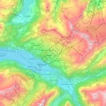
Nombre: Mapa topográfico Hasliberg, altitud, relieve.
Altitud media: 1.414 m
Altitud mínima: 574 m
Altitud máxima: 2.637 m
Haz una donación
Equípate para tu próxima aventura:
Como asociado de Amazon, este sitio gana comisiones por las compras que califican, sin ningún costo adicional para usted.
Otros mapas topográficos
Haga clic en un mapa para ver su topografía, su altitud y su relieve.
Titlis
Switzerland > Bern > Interlaken-Oberhasli administrative district > Innertkirchen
Altitud media: 2.520 m
Schilthorn
Switzerland > Bern > Interlaken-Oberhasli administrative district > Lauterbrunnen
Altitud media: 2.455 m
Burglauenen
Switzerland > Bern > Interlaken-Oberhasli administrative district > Grindelwald
Altitud media: 1.407 m
Brienz
Switzerland > Bern > Interlaken-Oberhasli administrative district > Brienz (BE)
Altitud media: 810 m
Haz una donación
Equípate para tu próxima aventura:
Como asociado de Amazon, este sitio gana comisiones por las compras que califican, sin ningún costo adicional para usted.
Ballenberg
Switzerland > Bern > Interlaken-Oberhasli administrative district > Hofstetten bei Brienz > Hofstetten
Altitud media: 774 m
Wellhorn
Switzerland > Bern > Interlaken-Oberhasli administrative district > Schattenhalb
Altitud media: 2.486 m