Geolocalizar

Mapa topográfico Sucat

Haga clic en el mapa para ver la altitud.

Acerca de este mapa

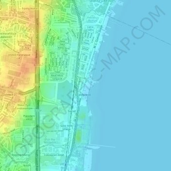
Nombre: Mapa topográfico Sucat, altitud, relieve.

Lugar: Sucat, Muntinlupa District 2, Muntinlupa, Southern Manila District, Metro Manila, Philippines (14.44355 121.03730 14.46797 121.05734)

Altitud media: 11 m

Altitud mínima: 1 m

Altitud máxima: 40 m

Otros mapas topográficos

Haga clic en un mapa para ver su topografía, su altitud y su relieve.

Tunasan River

Philippines > Muntinlupa

Altitud media: 47 m

Muntinlupa

Philippines > Muntinlupa

There are three plausible origins of the name of the city: First, is its association with the thin topsoil in the area; second, residents, purportedly replying to a question by Spaniards in the 16th century what the name of their place was, said “Monte sa Lupa”—apparently mistaking the question for what…

Altitud media: 41 m

Equípate para tu próxima aventura:

🧣Tubulares y Bragas de Cuello - Protección multifuncional contra el frío y el viento
🛰️Mensajería Satelital - Seguridad total donde no llega la cobertura móvil
🛠️Multiherramientas para Bici - Ajustes rápidos para no detener tu aventura
👖Mallas Térmicas Hombre - Capa base para mantener las piernas calientes
📦Bolsas estancas - Protección impermeable para equipo

Como asociado de Amazon, este sitio gana comisiones por las compras que califican, sin ningún costo adicional para usted.