
Haz una donación
Equípate para tu próxima aventura:
Como asociado de Amazon, este sitio gana comisiones por las compras que califican, sin ningún costo adicional para usted.
Mapa topográfico Clallam Bay
Haga clic en el mapa para ver la altitud.
Haz una donación
Equípate para tu próxima aventura:
Como asociado de Amazon, este sitio gana comisiones por las compras que califican, sin ningún costo adicional para usted.
Acerca de este mapa
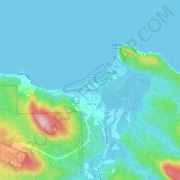
Nombre: Mapa topográfico Clallam Bay, altitud, relieve.
Lugar: Clallam Bay, Clallam County, Washington, United States (48.23399 -124.28070 48.27399 -124.24070)
Altitud media: 39 m
Altitud mínima: -2 m
Altitud máxima: 234 m
Haz una donación
Equípate para tu próxima aventura:
Como asociado de Amazon, este sitio gana comisiones por las compras que califican, sin ningún costo adicional para usted.
Otros mapas topográficos
Haga clic en un mapa para ver su topografía, su altitud y su relieve.
Port Angeles
United States > Washington > Clallam County
Port Angeles is characterized by a diverse and dramatic topography that reflects its unique geographic position on the Olympic Peninsula. Situated at approximately 72 feet above sea level, the city rises from the shores of the Strait of Juan de Fuca and is bordered by the Olympic Mountains to the south, which…
Altitud media: 27 m
Haz una donación
Equípate para tu próxima aventura:
Como asociado de Amazon, este sitio gana comisiones por las compras que califican, sin ningún costo adicional para usted.
Haz una donación
Equípate para tu próxima aventura:
Como asociado de Amazon, este sitio gana comisiones por las compras que califican, sin ningún costo adicional para usted.
Haz una donación
Equípate para tu próxima aventura:
Como asociado de Amazon, este sitio gana comisiones por las compras que califican, sin ningún costo adicional para usted.