
Mapa topográfico Primorsky Krai
Mapa interactivo
Haga clic en el mapa para ver la altitud.
Primorsky Krai
Highlands dominate the territory of the krai. Most of the territory is mountainous, and almost 80% of it is forested. The average elevation is about 500 meters (1,600 ft). Sikhote-Alin is a mountainous formation, extending for the most part of the Krai. It consists of a number of parallel ranges: the Partizansky (Partisan), the Siny (Blue), the Kholodny (Cold), and others. There are many karst caves in the South of Primorye. The relatively accessible Spyashchaya Krasavitsa cave (the Sleeping Beauty) in the Ussuriysky Nature Preserve could be recommended for tourists. There are comparatively well-preserved fragments of the ancient volcanoes in the area.
Acerca de este mapa
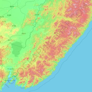
Nombre: Mapa topográfico Primorsky Krai, altitud, relieve.
Lugar: Primorsky Krai, Far Eastern Federal District, Russia (42.52195 132.16665 47.64195 137.28665)
Altitud media: 255 m
Altitud mínima: -2 m
Altitud máxima: 1.870 m
Otros mapas topográficos
Haga clic en un mapa para ver su topografía, su altitud y su relieve.