
Mapa topográfico Castle Douglas
Haga clic en el mapa para ver la altitud.
Acerca de este mapa
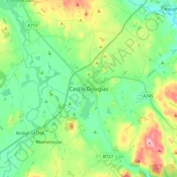
Nombre: Mapa topográfico Castle Douglas, altitud, relieve.
Altitud media: 68 m
Altitud mínima: 16 m
Altitud máxima: 184 m
Otros mapas topográficos
Haga clic en un mapa para ver su topografía, su altitud y su relieve.
Garden of Cosmic Speculation
United Kingdom > Scotland > Dumfries and Galloway > Burnhead
Altitud media: 31 m
Rhinns of Kellsc
United Kingdom > Scotland > Dumfries and Galloway
'Rhinns' derives from the Old Irish rind, later Ulster Irish and Scottish Gaelic rinn, meaning 'promontory' or 'point'. 'Kells' is a parish in the historic county of Stewartry of Kirkcudbright to the southeast of the range near New Galloway. Its name possibly derives from the Old Irish cell, later Irish and…
Altitud media: 352 m