
Mapa topográfico Richardière
Mapa interactivo
Haga clic en el mapa para ver la altitud.
Acerca de este mapa
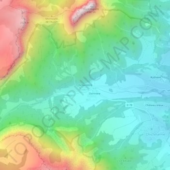
Nombre: Mapa topográfico Richardière, altitud, relieve.
Altitud media: 1.304 m
Altitud mínima: 951 m
Altitud máxima: 2.078 m
Otros mapas topográficos
Haga clic en un mapa para ver su topografía, su altitud y su relieve.
Donnière
France > Auvergne-Rhône-Alpes > Isère > Chichilianne > Donnière
Donnière, Chichilianne, Grenoble, Isère, Auvergne-Rhône-Alpes, France métropolitaine, 38930, France
Altitud media: 1.268 m
Charbonnier
France > Auvergne-Rhône-Alpes > Isère > Chichilianne
Charbonnier, Chichilianne, Grenoble, Isère, Auvergne-Rhône-Alpes, France métropolitaine, 38930, France
Altitud media: 1.125 m
Mont Aiguille
France > Auvergne-Rhône-Alpes > Isère > Chichilianne
Mont Aiguille, Chichilianne, Grenoble, Isère, Auvergne-Rhône-Alpes, France métropolitaine, 38930, France
Altitud media: 1.395 m
Les Oches
France > Auvergne-Rhône-Alpes > Isère > Chichilianne
Les Oches, Chichilianne, Grenoble, Isère, Auvergne-Rhône-Alpes, France métropolitaine, 38930, France
Altitud media: 1.131 m
Ruthière
France > Auvergne-Rhône-Alpes > Isère > Chichilianne
Ruthière, Chichilianne, Grenoble, Isère, Auvergne-Rhône-Alpes, France métropolitaine, 38930, France
Altitud media: 1.132 m
Prarron
France > Auvergne-Rhône-Alpes > Isère > Chichilianne > Château-Vieux
Prarron, Château-Vieux, Chichilianne, Grenoble, Isère, Auvergne-Rhône-Alpes, France métropolitaine, 38930, France
Altitud media: 1.071 m