
Mapa topográfico Bluefield
Mapa interactivo
Haga clic en el mapa para ver la altitud.
Acerca de este mapa
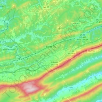
Nombre: Mapa topográfico Bluefield, altitud, relieve.
Altitud media: 819 m
Altitud mínima: 630 m
Altitud máxima: 1.248 m
Bluefield is a mountain city with a warm-summer humid continental climate (Dfb) bordering on subtropical highland climate or temperate oceanic climate (Cfb), due to its elevation. It is characterized by moderately cold, snowy winters and pleasantly warm to hot summers. The normal monthly mean daily temperature ranges from 31.9 °F (−0.1 °C) in January to 70.3 °F (21.3 °C) in July; on average, there are only 2.5 days with a maximum of at least 90 °F (32 °C) or greater maxima, 1.3 days of minima at or below 0 °F (−18 °C), and 23 days where the maximum does not rise above freezing. The hottest temperature ever recorded in the city was 99 °F (37 °C), set on July 28, 1952, and August 9, 1957, with the coldest temperature at −25 °F (−32 °C), set on December 30, 1917.
Otros mapas topográficos
Haga clic en un mapa para ver su topografía, su altitud y su relieve.
Dunns
United States > West Virginia > Mercer County > Dunns
Dunns, Mercer County, West Virginia, United States
Altitud media: 675 m