
Mapa topográfico Eastmeadow
Mapa interactivo
Haga clic en el mapa para ver la altitud.
Acerca de este mapa
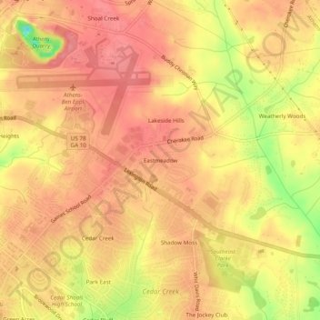
Nombre: Mapa topográfico Eastmeadow, altitud, relieve.
Altitud media: 223 m
Altitud mínima: 162 m
Altitud máxima: 249 m
Otros mapas topográficos
Haga clic en un mapa para ver su topografía, su altitud y su relieve.
Spring Valley Estates
United States > Georgia > Athens-Clarke County > Athens-Clarke County Unified Government
Spring Valley Estates, Athens-Clarke County Unified Government, Athens-Clarke County, Georgia, 30601, United States
Altitud media: 218 m
Jefferson Valley
United States > Georgia > Athens-Clarke County > Athens-Clarke County Unified Government
Jefferson Valley, Athens-Clarke County Unified Government, Athens-Clarke County, Georgia, 30607, United States
Altitud media: 223 m
Rollingwood
United States > Georgia > Athens-Clarke County > Athens-Clarke County Unified Government
Rollingwood, Athens-Clarke County Unified Government, Athens-Clarke County, Georgia, 30608, United States
Altitud media: 210 m
Shoal Creek Farms
United States > Georgia > Athens-Clarke County > Athens-Clarke County Unified Government
Shoal Creek Farms, Athens-Clarke County Unified Government, Athens-Clarke County, Georgia, United States
Altitud media: 205 m