Geolocalizar

Mapa topográfico Rathgar

Haga clic en el mapa para ver la altitud.

Acerca de este mapa

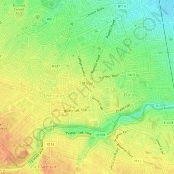
Nombre: Mapa topográfico Rathgar, altitud, relieve.

Lugar: Rathgar, Rathfarnham A ED, Dublin, County Dublin, Leinster, Ireland (53.30374 -6.28252 53.31860 -6.26372)

Altitud media: 40 m

Altitud mínima: 18 m

Altitud máxima: 56 m

Otros mapas topográficos

Haga clic en un mapa para ver su topografía, su altitud y su relieve.

Dublin Castle

Ireland > County Dublin > Dublin

The Poddle was diverted into the city through archways where the walls adjoined the castle, artificially flooding the moat of the fortress's city elevations. One of these archways and part of the wall survive buried underneath the 18th-century buildings, and are open for public viewing.

Altitud media: 16 m

Iveagh Gardens

Ireland > County Dublin > Dublin

Altitud media: 17 m

Griffith Park

Ireland > County Dublin > Dublin

Altitud media: 26 m

St Anne's Park

Ireland > County Dublin > Dublin

Altitud media: 13 m

Equípate para tu próxima aventura:

📚Guías de Senderismo por España - Las mejores rutas explicadas paso a paso
🧭Brújulas de orientación - Brújulas precisas para navegación y montaña
🔋Power banks solares - Energía portátil para actividades outdoor
🦟Repelentes de Insectos - Evita picaduras en zonas de vegetación densa
🧤Guantes Térmicos Táctiles - Protege tus manos sin dejar de usar tu GPS o móvil

Como asociado de Amazon, este sitio gana comisiones por las compras que califican, sin ningún costo adicional para usted.