
Haz una donación
Equípate para tu próxima aventura:
Como asociado de Amazon, este sitio gana comisiones por las compras que califican, sin ningún costo adicional para usted.
Mapa topográfico Philadelphia
Haga clic en el mapa para ver la altitud.
Haz una donación
Equípate para tu próxima aventura:
Como asociado de Amazon, este sitio gana comisiones por las compras que califican, sin ningún costo adicional para usted.
Acerca de este mapa
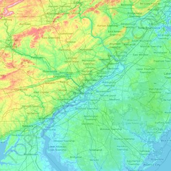
Nombre: Mapa topográfico Philadelphia, altitud, relieve.
Lugar: Philadelphia, Pennsylvania, 19140, United States (39.31145 -75.83265 40.71145 -74.43265)
Altitud media: 68 m
Altitud mínima: -4 m
Altitud máxima: 496 m
Haz una donación
Equípate para tu próxima aventura:
Como asociado de Amazon, este sitio gana comisiones por las compras que califican, sin ningún costo adicional para usted.
Otros mapas topográficos
Haga clic en un mapa para ver su topografía, su altitud y su relieve.
Pittsburgh
United States > Pennsylvania > Allegheny County
Pittsburgh, located in Allegheny County, Pennsylvania, is characterized by its distinct and varied topography, shaped by the confluence of the Allegheny, Monongahela, and Ohio rivers. The city itself is situated at an average elevation of approximately 764 feet (233 meters) above sea level, with the terrain…
Altitud media: 303 m
Philadelphia
United States > Pennsylvania > Philadelphia County
Philadelphia, located at the confluence of the Delaware and Schuylkill Rivers, features a diverse topography characterized by its gentle slopes and valleys. The city lies on the Atlantic Seaboard Fall Line, transitioning from the flat Coastal Plain to the more rugged Piedmont region. This unique geographical…
Altitud media: 44 m
Chester County
According to the U.S. Census Bureau, the county has a total area of 759 square miles (1,970 km2), of which 751 square miles (1,950 km2) is land and 8.7 square miles (23 km2) (1.1%) is water. The topography consists of rolling hills and valleys and it is part of the region known as the Piedmont.
Altitud media: 124 m
Haz una donación
Equípate para tu próxima aventura:
Como asociado de Amazon, este sitio gana comisiones por las compras que califican, sin ningún costo adicional para usted.
Allegheny County
Allegheny has a humid continental climate which is hot-summer, (Dfa) except in higher elevations, where it is warm-summer (Dfb).
Altitud media: 325 m
Haz una donación
Equípate para tu próxima aventura:
Como asociado de Amazon, este sitio gana comisiones por las compras que califican, sin ningún costo adicional para usted.
Erie County
Most of the county has a warm-summer humid continental climate (Dfb), except at lower elevations near enough to the lake, where a hot-summer humid continental climate (Dfa) exists. Average monthly temperatures in downtown Erie range from 26.4 °F in January to 70.8 °F in July, while in Corry they range from…
Altitud media: 248 m
Haz una donación
Equípate para tu próxima aventura:
Como asociado de Amazon, este sitio gana comisiones por las compras que califican, sin ningún costo adicional para usted.
Wilkes-Barre
United States > Pennsylvania > Luzerne County
According to the U.S. Census Bureau, the city has a total area of 7.2 square miles (19 km2), of which 6.8 square miles (18 km2) is land and 0.3 square miles (0.78 km2), or 4.60%, is water. The city is bordered by the Susquehanna River to the west. Most of Downtown is located on a wide floodplain. Floodwalls…
Altitud media: 218 m
Haz una donación
Equípate para tu próxima aventura:
Como asociado de Amazon, este sitio gana comisiones por las compras que califican, sin ningún costo adicional para usted.
Haz una donación
Equípate para tu próxima aventura:
Como asociado de Amazon, este sitio gana comisiones por las compras que califican, sin ningún costo adicional para usted.
State College
United States > Pennsylvania > Centre County
State College is situated at an elevation of approximately 1,200 feet (370 m) above sea level. According to the U.S. Census Bureau, the borough has a total area of 4.5 square miles (12 km2), all of it land. It is surrounded by large tracts of farmland, and an expanse of Appalachian Mountain ranges and forests.…
Altitud media: 351 m
Haz una donación
Equípate para tu próxima aventura:
Como asociado de Amazon, este sitio gana comisiones por las compras que califican, sin ningún costo adicional para usted.
Haz una donación
Equípate para tu próxima aventura:
Como asociado de Amazon, este sitio gana comisiones por las compras que califican, sin ningún costo adicional para usted.
Haz una donación
Equípate para tu próxima aventura:
Como asociado de Amazon, este sitio gana comisiones por las compras que califican, sin ningún costo adicional para usted.
Greenville
United States > Pennsylvania > Mercer County
Greenville is located in northwest Pennsylvania at 41°24′18″N 80°23′12″W / 41.40500°N 80.38667°W / 41.40500; -80.38667 (41.404998, −80.386651), along the Shenango River. Its altitude is 945 feet (288 m) above sea level.
Altitud media: 320 m
Haz una donación
Equípate para tu próxima aventura:
Como asociado de Amazon, este sitio gana comisiones por las compras que califican, sin ningún costo adicional para usted.
Erie County
Most of the county has a warm-summer humid continental climate (Dfb), except at lower elevations near enough to the lake, where a hot-summer humid continental climate (Dfa) exists. Average monthly temperatures in downtown Erie range from 26.4 °F in January to 70.8 °F in July, while in Corry they range from…
Altitud media: 248 m
Haz una donación
Equípate para tu próxima aventura:
Como asociado de Amazon, este sitio gana comisiones por las compras que califican, sin ningún costo adicional para usted.
South Mountain
United States > Pennsylvania > Lehigh County > Upper Saucon
Unlike Blue Mountain to its north, South Mountain does not follow a straight geographic line. The mountain ranges in elevation between 500 and 1,300 feet (150 and 400 m) above sea level. The ridge is made of metamorphic rocks and gneiss, which date to the Precambrian era and range from about 570 million to…
Altitud media: 153 m
Haz una donación
Equípate para tu próxima aventura:
Como asociado de Amazon, este sitio gana comisiones por las compras que califican, sin ningún costo adicional para usted.
Somerset County
Somerset County along with Garrett County is one of the snowiest inhabited locations in the United States, with the highest elevations of the county averaging 150+ inches of snow each winter. The county's elevation and general proximity to both the Great Lakes and the Atlantic Ocean causes snow from both…
Altitud media: 632 m
Haz una donación
Equípate para tu próxima aventura:
Como asociado de Amazon, este sitio gana comisiones por las compras que califican, sin ningún costo adicional para usted.
Luzerne County
The Wyoming Valley, also referred to as the Anthracite Valley Section of Pennsylvania, runs directly through Luzerne County. It extends from the northeastern border (with Lackawanna County) to the western border (with Columbia County). The valley is flat (at the Susquehanna Basin) and rises from 512 feet (156…
Altitud media: 402 m
Haz una donación
Equípate para tu próxima aventura:
Como asociado de Amazon, este sitio gana comisiones por las compras que califican, sin ningún costo adicional para usted.
Haz una donación
Equípate para tu próxima aventura:
Como asociado de Amazon, este sitio gana comisiones por las compras que califican, sin ningún costo adicional para usted.
Lehigh County
Lehigh County borders two Appalachian mountain ridges. To the north, the county borders Blue Mountain, which has an altitude of 1,300 to 1,604 feet (396 to 489 m). To the south, it is bordered by South Mountain, which has an altitude of 700 to 1,100 feet (210 to 340 m) and cuts through the southern portions of…
Altitud media: 186 m
Bucks County
According to the Trewartha climate classification system, the Piedmont (United States) section of Bucks County, which is located roughly northwest of U.S. Route 1, has a Temperate Continental Climate with hot and slightly humid summers, cold winters and year-around precipitation (Dcao). Dcao climates are…
Altitud media: 98 m
Haz una donación
Equípate para tu próxima aventura:
Como asociado de Amazon, este sitio gana comisiones por las compras que califican, sin ningún costo adicional para usted.
Centre County
Centre County has a humid continental climate (Dfb/Dfa at lower elevations).
Altitud media: 427 m
Haz una donación
Equípate para tu próxima aventura:
Como asociado de Amazon, este sitio gana comisiones por las compras que califican, sin ningún costo adicional para usted.
Haz una donación
Equípate para tu próxima aventura:
Como asociado de Amazon, este sitio gana comisiones por las compras que califican, sin ningún costo adicional para usted.
Haz una donación
Equípate para tu próxima aventura:
Como asociado de Amazon, este sitio gana comisiones por las compras que califican, sin ningún costo adicional para usted.
Haz una donación
Equípate para tu próxima aventura:
Como asociado de Amazon, este sitio gana comisiones por las compras que califican, sin ningún costo adicional para usted.
Sullivan County
Elevation ranges from 2593 ft at North Mountain in Davidson Township to 779 ft on Loyalsock Creek at the Lycoming County line. The county is served by Pennsylvania Route 42, Pennsylvania Route 87, Pennsylvania Route 154, Pennsylvania Route 487, and U.S. Route 220. The major rivers in the county are Loyalsock…
Altitud media: 491 m
Haz una donación
Equípate para tu próxima aventura:
Como asociado de Amazon, este sitio gana comisiones por las compras que califican, sin ningún costo adicional para usted.
Pike County
The terrain rises rapidly from the river valley in the east to the rolling foothills of the Poconos in the west. The highest point is one of two unnamed hills in Greene Township that top out at approximately 2,110 feet (643 m) above sea level. The lowest elevation is approximately 340 feet (103.6 m), at the…
Altitud media: 361 m
Haz una donación
Equípate para tu próxima aventura:
Como asociado de Amazon, este sitio gana comisiones por las compras que califican, sin ningún costo adicional para usted.
Haz una donación
Equípate para tu próxima aventura:
Como asociado de Amazon, este sitio gana comisiones por las compras que califican, sin ningún costo adicional para usted.
Monroe County
According to the Trewartha climate classification system, the higher elevation Pocono Plateau Region of Monroe County has a Temperate Continental climate (Dc) with warm summers (b), cold winters (o) and year-around precipitation (Dcbo). Dcbo climates are characterized by at least one month having an average…
Altitud media: 361 m
Haz una donación
Equípate para tu próxima aventura:
Como asociado de Amazon, este sitio gana comisiones por las compras que califican, sin ningún costo adicional para usted.
Wayne County
The highest elevation in the county, 2,659 ft (810 m), is the summit of Mount Ararat in Orson. Two other summits at the north end of the same ridge also exceed 2,640 ft (800 m) in elevation. The county's lowest point, at approximately 680 ft (210 m) above sea level, is along the Delaware, near Wayne County's…
Altitud media: 436 m
Export
United States > Pennsylvania > Westmoreland County
Export is characterized by a varied terrain that reflects its location in the Allegheny Plateau region. The borough sits at an average elevation of around 1,122 feet (342 meters) and features rolling hills and valleys typical of southwestern Pennsylvania's topography. The surrounding landscape is marked by…
Altitud media: 342 m
Haz una donación
Equípate para tu próxima aventura:
Como asociado de Amazon, este sitio gana comisiones por las compras que califican, sin ningún costo adicional para usted.
Montour County
Montour County is located in the Ridge-and-Valley Province of the Appalachian Mountains. A total of 65% of the soils in the county are well-drained. The Muncy Hills are located in the northern part of the county and Montour Ridge is located in the southern part of the county, not far from the Susquehanna…
Altitud media: 225 m
Haz una donación
Equípate para tu próxima aventura:
Como asociado de Amazon, este sitio gana comisiones por las compras que califican, sin ningún costo adicional para usted.