
Mapa topográfico Scranton
Mapa interactivo
Haga clic en el mapa para ver la altitud.
Acerca de este mapa
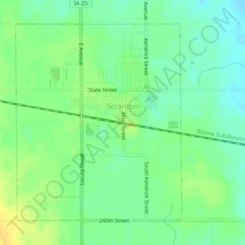
Nombre: Mapa topográfico Scranton, altitud, relieve.
Lugar: Scranton, Greene County, Iowa, 51462, United States (42.00830 -94.56140 42.03002 -94.53669)
Altitud media: 358 m
Altitud mínima: 347 m
Altitud máxima: 371 m
Otros mapas topográficos
Haga clic en un mapa para ver su topografía, su altitud y su relieve.
Jefferson
United States > Iowa > Greene County
Jefferson, Greene County, Iowa, 50129, United States
Altitud media: 319 m
Paton
United States > Iowa > Greene County
Paton, Greene County, Iowa, United States
Altitud media: 336 m
Rippey
United States > Iowa > Greene County
Rippey, Greene County, Iowa, United States
Altitud media: 323 m
Cooper
United States > Iowa > Greene County
Cooper, Greene County, Iowa, United States
Altitud media: 325 m
Churdan
United States > Iowa > Greene County
Churdan, Greene County, Iowa, 50050, United States
Altitud media: 339 m
Dana
United States > Iowa > Greene County
Dana, Greene County, Iowa, United States
Altitud media: 336 m
Grand Junction
United States > Iowa > Greene County
Grand Junction, Greene County, Iowa, United States
Altitud media: 314 m