
Mapa topográfico Lone Peak Wilderness
Mapa interactivo
Haga clic en el mapa para ver la altitud.
Acerca de este mapa
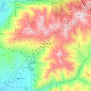
Nombre: Mapa topográfico Lone Peak Wilderness, altitud, relieve.
Altitud media: 2.367 m
Altitud mínima: 1.464 m
Altitud máxima: 3.480 m
The Lone Peak Wilderness provides a spectacular backdrop for the growing urban areas along the Wasatch Front and is dominated by rugged terrain, narrow canyons and high peaks, including the Pfeifferhorn, commonly referred to as Little Matterhorn Peak, at 11,326 feet (3,452 m) and Lone Peak at 11,253 feet (3,430 meters). The geologic structure of the area is varied and complex, consisting of granitoid rock masses and several sedimentary formations. Carving of the present alpine topography is due to glaciation, with erosion being the current dominant force in the land sculpturing process. Much of the higher elevation is alpine, characterized by large, open cirque basins and exposed rocky ridges. A few small natural and reservoired lakes add to the scenic beauty.