
Mapa topográfico Saratoga County
Mapa interactivo
Haga clic en el mapa para ver la altitud.
Acerca de este mapa
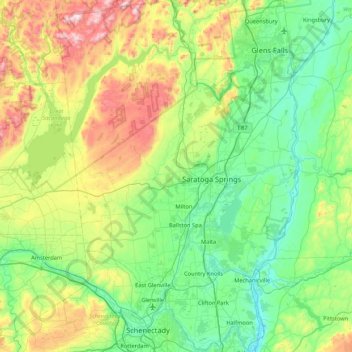
Nombre: Mapa topográfico Saratoga County, altitud, relieve.
Lugar: Saratoga County, New York, USA (42.77546 -74.16010 43.39797 -73.57327)
Altitud media: 218 m
Altitud mínima: 3 m
Altitud máxima: 833 m
Otros mapas topográficos
Haga clic en un mapa para ver su topografía, su altitud y su relieve.
Staten Island
Staten Island, Richmond County, New York, USA
Altitud media: 11 m
Chestnut Creek
Chestnut Creek, Town of Neversink, Sullivan County, New York, 12765, USA
Altitud media: 470 m
Gooseberry Hill
Gooseberry Hill, Essex County, New York, 12872, USA
Altitud media: 304 m
City of Saratoga Springs
USA > New York > City of Saratoga Springs
City of Saratoga Springs, Saratoga County, New York, USA
Altitud media: 95 m
Mount Warren
Mount Warren, Town of Bovina, Delaware County, New York, USA
Altitud media: 677 m
West Bay Shore
USA > New York > West Bay Shore
West Bay Shore, Suffolk County, New York, USA
Altitud media: 7 m
Roosevelt Island
USA > New York > New York City
Roosevelt Island, Manhattan Community Board 8, New York County, New York City, New York, 10044, USA
Altitud media: 13 m
Adirondack
USA > New York > Adirondack
Adirondack, Town of Horicon, Warren County, New York, 12808, USA
Altitud media: 294 m
Big Bear Mountain
Big Bear Mountain, Town of Johnsburg, Warren County, New York, USA
Altitud media: 616 m
Niagara Falls
USA > New York > Niagara Falls
Niagara Falls, Niagara County, New York, USA
Altitud media: 180 m
Avalanche Lake
Avalanche Lake, Avalanche Pass Trail, Essex County, New York, USA
Altitud media: 1.066 m
Livingston Island
Livingston Island, Town of Philipstown, Putnam County, New York, 10922, USA
Altitud media: 156 m