
Mapa topográfico North Cotes
Haga clic en el mapa para ver la altitud.
Acerca de este mapa
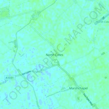
Nombre: Mapa topográfico North Cotes, altitud, relieve.
Altitud media: 3 m
Altitud mínima: -1 m
Altitud máxima: 6 m
Otros mapas topográficos
Haga clic en un mapa para ver su topografía, su altitud y su relieve.
Holton le Clay
United Kingdom > England > Lincolnshire > East Lindsey > Holton le Clay
Altitud media: 14 m
Skegness
United Kingdom > England > Lincolnshire > East Lindsey
Skegness fronts the North Sea. It is located on a low-lying flat region called Lincoln Marsh, which runs along the coast between Skegness and the Humber and separates the coast from the upland Wolds. Much of the parish's elevation is close to sea level, although a narrow band along the seafront is 4–5 m…
Altitud media: 2 m
Mareham le Fen
United Kingdom > England > Lincolnshire > East Lindsey > Mareham le Fen
Altitud media: 8 m
Wainfleet All Saints
United Kingdom > England > Lincolnshire > East Lindsey > Wainfleet St Mary
Altitud media: 3 m
Wainfleet Haven
United Kingdom > England > Lincolnshire > East Lindsey > Wainfleet Clough
Altitud media: 3 m
North Thoresby
United Kingdom > England > Lincolnshire > East Lindsey > North Thoresby
Altitud media: 26 m
Theddlethorpe All Saints
United Kingdom > England > Lincolnshire > East Lindsey > Theddlethorpe St Helen
Altitud media: 2 m
Louth Navigation
United Kingdom > England > Lincolnshire > East Lindsey > Alvingham
Altitud media: 8 m
Saltfleetby
United Kingdom > England > Lincolnshire > East Lindsey > Saltfleetby St Peter
Altitud media: 2 m
Hagworthingham
United Kingdom > England > Lincolnshire > East Lindsey > Hagworthingham
Altitud media: 70 m
North Somercotes
United Kingdom > England > Lincolnshire > East Lindsey > North Somercotes
Altitud media: 1 m
Great Steeping
United Kingdom > England > Lincolnshire > East Lindsey > Great Steeping
Altitud media: 9 m
Yarburgh
United Kingdom > England > Lincolnshire > East Lindsey > Covenham St. Mary
Altitud media: 11 m
Little Carlton
United Kingdom > England > Lincolnshire > East Lindsey > Little Carlton
Altitud media: 11 m
Maltby le Marsh
United Kingdom > England > Lincolnshire > East Lindsey > Maltby Le Marsh
Altitud media: 4 m