
Haz una donación
Equípate para tu próxima aventura:
Como asociado de Amazon, este sitio gana comisiones por las compras que califican, sin ningún costo adicional para usted.
Mapa topográfico Honey Grove
Haga clic en el mapa para ver la altitud.
Haz una donación
Equípate para tu próxima aventura:
Como asociado de Amazon, este sitio gana comisiones por las compras que califican, sin ningún costo adicional para usted.
Honey Grove
Honey Grove is in central North Texas, in eastern Fannin County, 16 miles (26 km) east of Bonham, the county seat, 39 miles (63 km) north of Greenville, 42 miles (68 km) east of Sherman, and 90 miles (140 km) northeast of the central business district of Dallas. Honey Grove was developed on flat to gently rolling terrain with scattered trees. The city is at an elevation ranging from about 580 to 690 feet (180 to 210 m) above sea level. U.S. Highway 82 and State Highway 56 traverse the city from east to west, and State Roads 34, 100, and 824 run north and south. Bonham is the closest major economic center. Its climate produces an annual average daily maximum temperature of 75.1 °F, and an average annual rainfall is 43.99 inches (1,117 mm). It is also a part of the Texoma region.
Haz una donación
Equípate para tu próxima aventura:
Como asociado de Amazon, este sitio gana comisiones por las compras que califican, sin ningún costo adicional para usted.
Acerca de este mapa
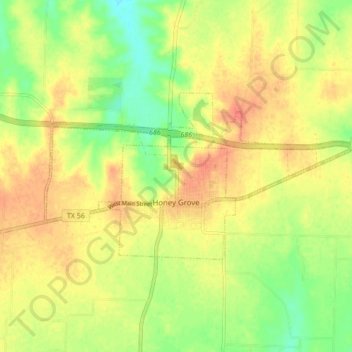
Nombre: Mapa topográfico Honey Grove, altitud, relieve.
Lugar: Honey Grove, Fannin County, Texas, United States (33.57186 -95.94192 33.60558 -95.85660)
Altitud media: 195 m
Altitud mínima: 169 m
Altitud máxima: 215 m
Haz una donación
Equípate para tu próxima aventura:
Como asociado de Amazon, este sitio gana comisiones por las compras que califican, sin ningún costo adicional para usted.
Otros mapas topográficos
Haga clic en un mapa para ver su topografía, su altitud y su relieve.
Haz una donación
Equípate para tu próxima aventura:
Como asociado de Amazon, este sitio gana comisiones por las compras que califican, sin ningún costo adicional para usted.