
Haz una donación
Equípate para tu próxima aventura:
Como asociado de Amazon, este sitio gana comisiones por las compras que califican, sin ningún costo adicional para usted.
Mapa topográfico Le Markstein
Haga clic en el mapa para ver la altitud.
Haz una donación
Equípate para tu próxima aventura:
Como asociado de Amazon, este sitio gana comisiones por las compras que califican, sin ningún costo adicional para usted.
Le Markstein
Le Markstein is a winter sports station in the Vosges mountains in France situated at an altitude of between 1,020 m (3,346 ft) and 1,268 m (4,160 ft) which is located on the Route des Crêtes. It forms a set of cross-country skiing with the Breitfirst ski-station and the Grand Ballon. The highest point is the summit of the Jungfraukopf. The station staged World Cup skiing in 1983 and 1987 and World Cup Paragliding in 1999. The roads through the station are also used from time to time by the Tour de France cycle race, including twice in 2014.
Haz una donación
Equípate para tu próxima aventura:
Como asociado de Amazon, este sitio gana comisiones por las compras que califican, sin ningún costo adicional para usted.
Acerca de este mapa
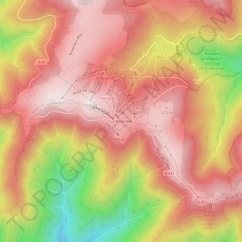
Nombre: Mapa topográfico Le Markstein, altitud, relieve.
Altitud media: 1.013 m
Altitud mínima: 552 m
Altitud máxima: 1.263 m
Haz una donación
Equípate para tu próxima aventura:
Como asociado de Amazon, este sitio gana comisiones por las compras que califican, sin ningún costo adicional para usted.