
Haz una donación
Equípate para tu próxima aventura:
Como asociado de Amazon, este sitio gana comisiones por las compras que califican, sin ningún costo adicional para usted.
Mapa topográfico Hanging Rock
Haga clic en el mapa para ver la altitud.
Haz una donación
Equípate para tu próxima aventura:
Como asociado de Amazon, este sitio gana comisiones por las compras que califican, sin ningún costo adicional para usted.
Acerca de este mapa
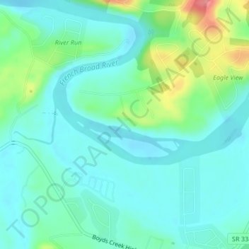
Nombre: Mapa topográfico Hanging Rock, altitud, relieve.
Altitud media: 281 m
Altitud mínima: 259 m
Altitud máxima: 350 m
Haz una donación
Equípate para tu próxima aventura:
Como asociado de Amazon, este sitio gana comisiones por las compras que califican, sin ningún costo adicional para usted.
Otros mapas topográficos
Haga clic en un mapa para ver su topografía, su altitud y su relieve.
Douglas Dam
United States > Tennessee > Sevier County > Sevierville
The Douglas Project required the construction of ten smaller, earthen saddle dams to fill in gaps along the adjacent ridgeline and permit a higher water elevation than would otherwise be possible. Most of these saddle dams are located in the hills southeast of the main dam. One protects downtown Dandridge,…
Altitud media: 312 m