
Mapa topográfico Eastern West Khasi Hills District
Mapa interactivo
Haga clic en el mapa para ver la altitud.
Acerca de este mapa
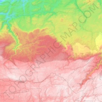
Nombre: Mapa topográfico Eastern West Khasi Hills District, altitud, relieve.
Lugar: Eastern West Khasi Hills District, Meghalaya, 793120, India (25.46964 91.34291 25.82786 91.81415)
Altitud media: 1.176 m
Altitud mínima: 59 m
Altitud máxima: 1.952 m
The Mawthadraishan Range runs east to west through the district. The highest elevation in the district is Mawthadraishan Peak at 1,924.5 metres (6,314 ft) above sea level, located approximately midway between the towns of Nongstoin and Mairang. Another notable elevation in the district is Kyllang Rock, a large granitic dome located 9 kilometres (5.6 mi) northwest of Mairang at 1,774 metres (5,820 ft) above sea level. This rock is personified as a man in various Khasi legends: one says that he is married to Thadlaskein Lake near Jowai, and another describes his battles with Symper Rock to the south near Mawkyrwat.
Otros mapas topográficos
Haga clic en un mapa para ver su topografía, su altitud y su relieve.
Khasi Hills
India > Meghalaya > Mawshynrut
Khasi Hills, Mawshynrut, West Khasi Hills District, Meghalaya, India
Altitud media: 349 m