
Mapa topográfico Sudden Valley
Mapa interactivo
Haga clic en el mapa para ver la altitud.
Acerca de este mapa
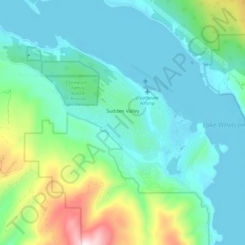
Nombre: Mapa topográfico Sudden Valley, altitud, relieve.
Lugar: Sudden Valley, Whatcom County, Washington, United States (48.69076 -122.39572 48.74909 -122.30380)
Altitud media: 239 m
Altitud mínima: 87 m
Altitud máxima: 800 m
Otros mapas topográficos
Haga clic en un mapa para ver su topografía, su altitud y su relieve.
Point Roberts
United States > Washington > Whatcom County > Point Roberts
Point Roberts, Whatcom County, Washington, 98281, United States
Altitud media: 9 m
Birch Bay
United States > Washington > Whatcom County
Birch Bay, Whatcom County, Washington, United States
Altitud media: 21 m
Maple Falls
United States > Washington > Whatcom County
Maple Falls, Whatcom County, Washington, United States
Altitud media: 442 m
Ferndale
United States > Washington > Whatcom County
Ferndale, Whatcom County, Washington, United States
Altitud media: 29 m
Lynden
United States > Washington > Whatcom County
Lynden, Whatcom County, Washington, United States
Altitud media: 26 m
Sumas
United States > Washington > Whatcom County
Sumas, Whatcom County, Washington, 98295, United States
Altitud media: 15 m
Mount Baker
United States > Washington > Whatcom County
Mount Baker, Whatcom County, Washington, United States
Altitud media: 2.699 m
Bellingham
United States > Washington > Whatcom County
Bellingham, Whatcom County, Washington, United States
Altitud media: 89 m
Blaine
United States > Washington > Whatcom County
Blaine, Whatcom County, Washington, 98231, United States
Altitud media: 23 m
Newhalem
United States > Washington > Whatcom County
Newhalem, Whatcom County, Washington, United States
Altitud media: 492 m