
Mapa topográfico Johns Creek
Mapa interactivo
Haga clic en el mapa para ver la altitud.
Acerca de este mapa
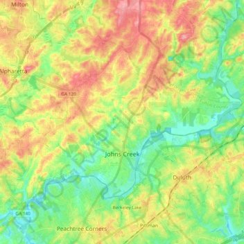
Nombre: Mapa topográfico Johns Creek, altitud, relieve.
Lugar: Johns Creek, Fulton County, Georgia, United States (33.98539 -84.28588 34.09068 -84.09769)
Altitud media: 314 m
Altitud mínima: 266 m
Altitud máxima: 380 m
Johns Creek is located in northeastern Fulton County and is centered at 34°1′44″N 84°11′55″W / 34.02889°N 84.19861°W / 34.02889; -84.19861 (34.0289259, -84.1985790). The elevation ranges from 880 feet (270 m) above sea level along the Chattahoochee River to 1,180 feet (360 m) in the Ocee area along the Alpharetta border. Johns Creek is bounded to the south by the Chattahoochee River and Gwinnett County, and on the northeast by McGinnis Ferry Road and Forsyth County. It is bounded by Roswell to the west, Alpharetta to the northwest, Suwanee to the east, and Duluth, Berkeley Lake, and Peachtree Corners to the south. Downtown Atlanta is 27 miles (43 km) to the southwest.
Otros mapas topográficos
Haga clic en un mapa para ver su topografía, su altitud y su relieve.
Roswell
United States > Georgia > Fulton County
Roswell, Fulton County, Georgia, United States
Altitud media: 316 m
Union City
United States > Georgia > Fulton County
Union City, Fulton County, Georgia, United States
Altitud media: 284 m
Shake Rag
United States > Georgia > Fulton County > Johns Creek
Shake Rag, Johns Creek, Fulton County, Georgia, 30095, United States
Altitud media: 300 m
Bamboo Forest
United States > Georgia > Fulton County > Sandy Springs
Bamboo Forest, Sandy Springs, Fulton County, Georgia, 30339, United States
Altitud media: 278 m
Atlanta
United States > Georgia > Fulton County
Atlanta, Fulton County, Georgia, United States
Altitud media: 284 m
Sandy Springs
United States > Georgia > Fulton County
Sandy Springs, Fulton County, Georgia, United States
Altitud media: 301 m
South Fulton
United States > Georgia > Fulton County
South Fulton, Fulton County, Georgia, United States
Altitud media: 272 m
Chattahoochee Hills
United States > Georgia > Fulton County
Chattahoochee Hills, Fulton County, Georgia, United States
Altitud media: 261 m
Piedmont Park
United States > Georgia > Fulton County > Atlanta
Piedmont Park, Atlanta, Fulton County, Georgia, 30306, United States
Altitud media: 283 m
Boulder Park
United States > Georgia > Fulton County > Atlanta
Boulder Park, Atlanta, Fulton County, Georgia, 30336, United States
Altitud media: 257 m
East Point
United States > Georgia > Fulton County
East Point, Fulton County, Georgia, 30344, United States
Altitud media: 295 m
Atlanta
United States > Georgia > Fulton County
Atlanta, Fulton County, Georgia, 30303, United States
Altitud media: 285 m
Johns Creek
United States > Georgia > Fulton County > Johns Creek > Johns Creek
Johns Creek, Fulton County, Georgia, 30097, United States
Altitud media: 305 m
Roswell
United States > Georgia > Fulton County > Roswell
Roswell, Fulton County, Georgia, 30077, United States
Altitud media: 312 m
Alpharetta
United States > Georgia > Fulton County > Alpharetta
Alpharetta, Fulton County, Georgia, 300009, United States
Altitud media: 325 m
Johns Creek
United States > Georgia > Fulton County > Johns Creek
Johns Creek, Fulton County, Georgia, 30097, United States
Altitud media: 314 m
Simsville
United States > Georgia > Fulton County > Atlanta > Simsville
Simsville, Atlanta, Fulton County, Georgia, 30318, United States
Altitud media: 275 m
Alpharetta
United States > Georgia > Fulton County
Alpharetta, Fulton County, Georgia, United States
Altitud media: 324 m
Milton
United States > Georgia > Fulton County
Milton, Fulton County, Georgia, 30004, United States
Altitud media: 330 m
Mountain Park
United States > Georgia > Fulton County
Mountain Park, Fulton County, Georgia, United States
Altitud media: 312 m
Palmetto
United States > Georgia > Fulton County
Palmetto, Fulton County, Georgia, 30268, United States
Altitud media: 291 m